
Topografische Karte Reading
Klicken Sie auf die Karte, um die Höhe anzuzeigen.
Reading
Mary Russell Mitford lived in Reading for a number of years and then spent the rest of her life just outside the town at Three Mile Cross and Swallowfield. The fictional Belford Regis of her eponymous novel, first published in 1835, is largely based on Reading. Described with topographical accuracy, it is still possible to follow the steps of the novel's characters in present-day Reading.
Über diese Karte
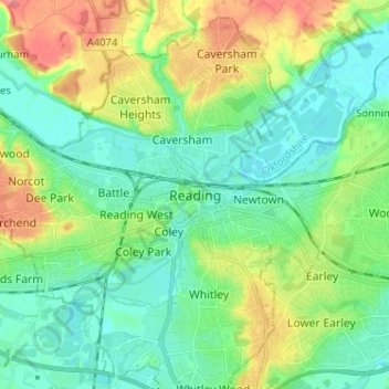
Name: Topografische Karte Reading, Höhe, Relief.
Ort: Reading, England, RG1 1JL, United Kingdom (51.41642 -1.01007 51.49642 -0.93007)
Durchschnittliche Höhe: 56 m
Minimale Höhe: 32 m
Maximale Höhe: 108 m
Andere topografische Karten
Klicken Sie auf eine Karte, um ihre Topografie, ihre Höhe und ihr Relief anzuzeigen.
Berkshire
United Kingdom > England > Reading
All of the county is drained by the Thames. Berkshire divides into two topological (and associated geological) sections: east and west of Reading. North-east Berkshire has the low calciferous (limestone) m-shaped bends of the Thames south of which is a broader, clayey, gravelly former watery plain or belt from…
Durchschnittliche Höhe: 100 m