Geolokalisieren
👉 Easily get elevation data in JSON, GeoTIFF and KML formats using Elevation API
Vielen Dank für die Unterstützung dieser Website ❤️
Spenden

Topografische Karte Rio Arade

Klicken Sie auf die Karte, um die Höhe anzuzeigen.

👉 Easily get elevation data in JSON, GeoTIFF and KML formats using Elevation API
Vielen Dank für die Unterstützung dieser Website ❤️
Spenden

Über diese Karte

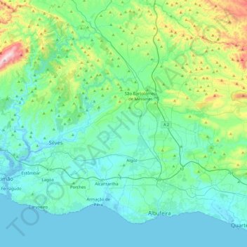
Name: Topografische Karte Rio Arade, Höhe, Relief.

Ort: Rio Arade, Faro, Portugal (37.10842 -8.53291 37.32436 -8.08856)

Durchschnittliche Höhe: 132 m

Minimale Höhe: -5 m

Maximale Höhe: 754 m

👉 Easily get elevation data in JSON, GeoTIFF and KML formats using Elevation API
Vielen Dank für die Unterstützung dieser Website ❤️
Spenden

Andere topografische Karten

Klicken Sie auf eine Karte, um ihre Topografie, ihre Höhe und ihr Relief anzuzeigen.

Goldra

Portugal > Faro > Loulé

Durchschnittliche Höhe: 224 m

Querença

Portugal > Faro > Querença, Tôr e Benafim

Durchschnittliche Höhe: 228 m

Praia de Vilamoura

Portugal > Faro > Quarteira

Durchschnittliche Höhe: 7 m

Rio Séqua

Portugal > Faro > Tavira > Barranco da Nora

Durchschnittliche Höhe: 70 m

Vielen Dank für die Unterstützung dieser Website ❤️
Spenden

Serra de Monchique

Portugal > Faro > Monchique

Durchschnittliche Höhe: 402 m

Funchais

Portugal > Faro > São Brás de Alportel

Durchschnittliche Höhe: 221 m

Besteiros

Portugal > Faro > Loulé > Ameixial

Durchschnittliche Höhe: 449 m

Foupana

Portugal > Faro > Olhão

Durchschnittliche Höhe: 118 m

Vielen Dank für die Unterstützung dieser Website ❤️
Spenden

Areal Gordo

Portugal > Faro > Faro

Durchschnittliche Höhe: 19 m

Bela Curral

Portugal > Faro > Faro > Conceição

Durchschnittliche Höhe: 30 m

Estevais

Portugal > Faro > São Bartolomeu de Messines

Durchschnittliche Höhe: 224 m

Arrizada

Portugal > Faro > Martim Longo

Durchschnittliche Höhe: 276 m

Vielen Dank für die Unterstützung dieser Website ❤️
Spenden

Pégada

Portugal > Faro > Tavira

Durchschnittliche Höhe: 26 m

Poio

Portugal > Faro > Portimão > Mexilhoeira Grande

Durchschnittliche Höhe: 44 m

Boucinhas

Portugal > Faro > Monchique

Durchschnittliche Höhe: 320 m

Porto de Lagos

Portugal > Faro > Portimão

Durchschnittliche Höhe: 43 m

Vielen Dank für die Unterstützung dieser Website ❤️
Spenden

Vale da Telha

Portugal > Faro > Aljezur

Durchschnittliche Höhe: 60 m

Marlin

Portugal > Faro > Tavira

Durchschnittliche Höhe: 25 m

Gateiras

Portugal > Faro > Algoz e Tunes > Tunes

Durchschnittliche Höhe: 91 m

Centieira

Portugal > Faro > Albufeira > Paderne

Durchschnittliche Höhe: 101 m

Vielen Dank für die Unterstützung dieser Website ❤️
Spenden

Furadouro

Portugal > Faro > Silves

Durchschnittliche Höhe: 35 m

Praia da Amoreira

Portugal > Faro > Aljezur

Durchschnittliche Höhe: 20 m

Zambujal

Portugal > Faro > Vaqueiros

Durchschnittliche Höhe: 230 m

Almádena

Portugal > Faro > Lagos

Durchschnittliche Höhe: 37 m

Vielen Dank für die Unterstützung dieser Website ❤️
Spenden

Lombada

Portugal > Faro > Loulé > Boliqueime

Durchschnittliche Höhe: 146 m

Calada

Portugal > Faro > Tavira

Durchschnittliche Höhe: 34 m

Algarve

Portugal > Faro > Loulé

O Algarve confina a norte com a região do Alentejo (sub-regiões do Alentejo Litoral e Baixo Alentejo), a sul e oeste com o oceano Atlântico, e a leste o Rio Guadiana marca a fronteira com Espanha. O ponto mais alto situa-se na serra de Monchique, com uma altitude máxima de 902 m (Pico da Foia).

Durchschnittliche Höhe: 72 m

Jogo

Portugal > Faro > Monchique

Durchschnittliche Höhe: 204 m

Vielen Dank für die Unterstützung dieser Website ❤️
Spenden

Praia da Luz

Portugal > Faro > Lagos

Durchschnittliche Höhe: 34 m

Fonte do Bispo

Portugal > Faro > Tavira > Santa Catarina da Fonte do Bispo

Durchschnittliche Höhe: 162 m

Fóia

Portugal > Faro > Monchique

Foia (antes do Acordo Ortográfico, Fóia) é o ponto mais alto do Algarve, situado na serra de Monchique. É acessível por estrada a partir da vila de Monchique. Tem 902 m de altitude e uma proeminência topográfica de 739 m e um isolamento topográfico de 172,69 km (o pico mais alto mais próximo é o…

Durchschnittliche Höhe: 724 m

Vale Telheiro

Portugal > Faro > Loulé

Durchschnittliche Höhe: 217 m

Vielen Dank für die Unterstützung dieser Website ❤️
Spenden

Cotifo

Portugal > Faro > Lagos

Durchschnittliche Höhe: 62 m

Monte Clérigo

Portugal > Faro > Aljezur

Durchschnittliche Höhe: 23 m

Praia da Rocha

Portugal > Faro > Portimão

Durchschnittliche Höhe: 7 m

Praia da Fuseta-Mar

Portugal > Faro > Moncarapacho e Fuseta > Fuzeta

Durchschnittliche Höhe: 2 m

Vielen Dank für die Unterstützung dieser Website ❤️
Spenden

Praia da Ilha de Tavira

Portugal > Faro > Tavira

Durchschnittliche Höhe: 1 m

Praia da Manta Rota

Portugal > Faro > Vila Nova de Cacela > Manta Rota

Durchschnittliche Höhe: 7 m

Lagos

Portugal > Faro

Durchschnittliche Höhe: 42 m

Praia da Salema

Portugal > Faro > Budens > Salema

Durchschnittliche Höhe: 24 m

Vielen Dank für die Unterstützung dieser Website ❤️
Spenden

Praia da Alagoa

Portugal > Faro > Castro Marim

Durchschnittliche Höhe: 5 m

Praia de Monte Gordo

Portugal > Faro > Monte Gordo

Durchschnittliche Höhe: 3 m

Praia de Odeceixe-Mar

Portugal > Faro > Odeceixe > Praia de Odeceixe

Durchschnittliche Höhe: 30 m

Praia do Barril

Portugal > Faro

Durchschnittliche Höhe: 2 m

Vielen Dank für die Unterstützung dieser Website ❤️
Spenden

Praia do Beliche

Portugal > Faro > Sagres > Sagres

Durchschnittliche Höhe: 29 m

Quatrim do Sul

Portugal > Faro > Olhão > Moncarapacho

Durchschnittliche Höhe: 18 m

Raposeira

Portugal > Faro > Vila do Bispo

Durchschnittliche Höhe: 86 m

Paderne

Portugal > Faro > Paderne > Paderne

Durchschnittliche Höhe: 87 m

Vielen Dank für die Unterstützung dieser Website ❤️
Spenden

Tavira

Portugal > Faro > Tavira

O relevo é plano no litoral e muito acidentado na região serrana, na qual alguns picos ultrapassam os 500 metros de altitude. O município é atravessado por diversos cursos de água, tais como o Rio Gilão (também conhecido como Rio Séqua, ou Ribeira da Asseca), a ribeira do Almargem ou o Rio Vascão. No…

Durchschnittliche Höhe: 88 m

Quinta das Raposeiras

Portugal > Faro > Faro > Santa Bárbara de Nexe

Durchschnittliche Höhe: 256 m

Ribeira de Alte

Portugal > Faro > Paderne > Ribeira de Alte

Durchschnittliche Höhe: 97 m

Vielen Dank für die Unterstützung dieser Website ❤️
Spenden

Albufeira

Portugal > Faro

Durchschnittliche Höhe: 50 m

Vale Covo

Portugal > Faro > Tavira

Durchschnittliche Höhe: 307 m

Estorninhos

Portugal > Faro > Tavira

Durchschnittliche Höhe: 173 m

Vale da Vila

Portugal > Faro > São Marcos da Serra

Durchschnittliche Höhe: 152 m

Vielen Dank für die Unterstützung dieser Website ❤️
Spenden

Serra

Portugal > Faro > Algoz e Tunes

Durchschnittliche Höhe: 47 m

Alcaria do Cume

Portugal > Faro > Tavira

Durchschnittliche Höhe: 399 m

Portugal

Portugal > Faro > São Marcos da Serra

Durchschnittliche Höhe: 201 m

Portela das Eiras

Portugal > Faro > Monchique

Durchschnittliche Höhe: 573 m

Vielen Dank für die Unterstützung dieser Website ❤️
Spenden

Barbelote

Portugal > Faro > Monchique

Durchschnittliche Höhe: 594 m

Odelouca

Portugal > Faro > Silves

Durchschnittliche Höhe: 49 m

Vale Fuzeiros

Portugal > Faro > São Bartolomeu de Messines

Durchschnittliche Höhe: 132 m

Piares

Portugal > Faro > Olhão > Quelfes

Durchschnittliche Höhe: 26 m

Vielen Dank für die Unterstützung dieser Website ❤️
Spenden

Alferce

Portugal > Faro > Monchique

Durchschnittliche Höhe: 297 m

Várzea do Vinagre

Portugal > Faro > Tavira

Durchschnittliche Höhe: 183 m

Fontes

Portugal > Faro > Estômbar e Parchal > Estômbar

Durchschnittliche Höhe: 28 m

Castelos

Portugal > Faro > Tavira

Durchschnittliche Höhe: 252 m

Vielen Dank für die Unterstützung dieser Website ❤️
Spenden

Caiana

Portugal > Faro > Tavira

Durchschnittliche Höhe: 36 m

Fortaleza de Sagres

Portugal > Faro > Vila do Bispo

O forte está situado num promontório escarpado a Leste do Cabo de São Vicente, com cerca de um quilómetro de comprimento, 300 m de largura e 40 m de altitude, tendo sido escolhido devido à sua posição privilegiada para controlar a costa. Faz parte do Parque Natural do Sudoeste Alentejano e Costa…

Durchschnittliche Höhe: 6 m

Lobite

Portugal > Faro > Silves

Durchschnittliche Höhe: 55 m

Alta Mora

Portugal > Faro > Castro Marim

Durchschnittliche Höhe: 192 m

Vielen Dank für die Unterstützung dieser Website ❤️
Spenden

Poço Seco

Portugal > Faro > Portimão

Durchschnittliche Höhe: 26 m

Cortelha

Portugal > Faro > Salir

Durchschnittliche Höhe: 438 m

Vale Figueira

Portugal > Faro > São Bartolomeu de Messines

Durchschnittliche Höhe: 148 m

Vale Touriz

Portugal > Faro > São Marcos da Serra

Durchschnittliche Höhe: 161 m

Vielen Dank für die Unterstützung dieser Website ❤️
Spenden

Benafim

Portugal > Faro > Loulé

Durchschnittliche Höhe: 257 m

Fundo

Portugal > Faro > Tavira

Durchschnittliche Höhe: 39 m

Alcaria Cova

Portugal > Faro > Faro

Durchschnittliche Höhe: 181 m

Meia Arraia

Portugal > Faro > Tavira

Durchschnittliche Höhe: 59 m

Vielen Dank für die Unterstützung dieser Website ❤️
Spenden

Praia Verde

Portugal > Faro > Castro Marim

Durchschnittliche Höhe: 7 m

Monte do Trigo

Portugal > Faro > São Brás de Alportel

Durchschnittliche Höhe: 181 m

Canais

Portugal > Faro > Ferreiras

Durchschnittliche Höhe: 95 m

Vielen Dank für die Unterstützung dieser Website ❤️
Spenden

Murtais

Portugal > Faro > Moncarapacho e Fuseta > Moncarapacho

Durchschnittliche Höhe: 34 m

Baiães

Portugal > Faro > Algoz e Tunes > Algoz

Durchschnittliche Höhe: 67 m

Belo Romão

Portugal > Faro > Moncarapacho e Fuseta > Moncarapacho

Durchschnittliche Höhe: 27 m

Parises

Portugal > Faro > São Brás de Alportel

Durchschnittliche Höhe: 402 m

Vielen Dank für die Unterstützung dieser Website ❤️
Spenden

Picota

Portugal > Faro > Tavira

Durchschnittliche Höhe: 94 m

Fonte e Azeda

Portugal > Faro > Castro Marim

Durchschnittliche Höhe: 13 m

Monte Canelas

Portugal > Faro > Portimão > Mexilhoeira Grande

Durchschnittliche Höhe: 50 m

Peral

Portugal > Faro > São Brás de Alportel

Durchschnittliche Höhe: 216 m

Vielen Dank für die Unterstützung dieser Website ❤️
Spenden

Marim

Portugal > Faro > Quelfes

Durchschnittliche Höhe: 18 m

Odelouca

Portugal > Faro > Silves

Durchschnittliche Höhe: 40 m

Corte do Gago

Portugal > Faro > Castro Marim > Azinhal

Durchschnittliche Höhe: 126 m

Azinheiro

Portugal > Faro > Faro

Durchschnittliche Höhe: 211 m

Vielen Dank für die Unterstützung dieser Website ❤️
Spenden

Estômbar

Portugal > Faro > Estômbar e Parchal

Durchschnittliche Höhe: 34 m

Sobral de Cima

Portugal > Faro > Porches

Durchschnittliche Höhe: 58 m

Corotelo

Portugal > Faro > São Brás de Alportel

Durchschnittliche Höhe: 269 m

Alportel

Portugal > Faro > São Brás de Alportel

Durchschnittliche Höhe: 306 m

Vielen Dank für die Unterstützung dieser Website ❤️
Spenden