Geolokalisieren

Topografische Karte Areal Gordo

Interaktive Karte

Klicken Sie auf die Karte, um die Höhe anzuzeigen.

Über diese Karte

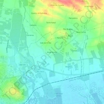
Name: Topografische Karte Areal Gordo, Höhe, Relief.

Ort: Areal Gordo, Faro (Sé e São Pedro), Faro, 8005-409, Portugal (37.01463 -7.92260 37.05463 -7.88260)

Durchschnittliche Höhe: 19 m

Minimale Höhe: -1 m

Maximale Höhe: 70 m

Andere topografische Karten

Klicken Sie auf eine Karte, um ihre Topografie, ihre Höhe und ihr Relief anzuzeigen.

Montenegro

Portugal > Faro > Faro

Montenegro, Faro, Portugal

Durchschnittliche Höhe: 8 m

Alcaria Cova

Portugal > Faro > Faro

Alcaria Cova, Conceição e Estoi, Faro, 8005-405, Portugal

Durchschnittliche Höhe: 181 m

Bela Curral

Portugal > Faro > Faro

Bela Curral, Conceição e Estoi, Faro, 8005-418, Portugal

Durchschnittliche Höhe: 30 m

Santa Bárbara de Nexe

Portugal > Faro > Faro

Santa Bárbara de Nexe, Faro, Portugal

Durchschnittliche Höhe: 160 m

Quinta das Raposeiras

Portugal > Faro > Faro > Quinta das Raposeiras

Quinta das Raposeiras, Santa Bárbara de Nexe, Faro, 8005-423, Portugal

Durchschnittliche Höhe: 256 m

Praia da Ilha de Faro

Portugal > Faro > Faro > Almancil

Praia da Ilha de Faro, Almancil, Faro, Loulé, Faro, Portugal

Durchschnittliche Höhe: 1 m

Conceição

Portugal > Faro > Faro > Conceição

Conceição, Faro, 8005-446, Portugal

Durchschnittliche Höhe: 41 m

Arábia

Portugal > Faro > Faro > Montenegro > Arábia

Arábia, Montenegro, Faro, 8001-701, Portugal

Durchschnittliche Höhe: 5 m

Guilhim

Portugal > Faro > Faro

Guilhim, Faro, 8005-517, Portugal

Durchschnittliche Höhe: 155 m

Estoi

Portugal > Faro > Faro

Estoi, Faro, 8005-475, Portugal

Durchschnittliche Höhe: 117 m