
Topografische Karte Kilcruaig
Klicken Sie auf die Karte, um die Höhe anzuzeigen.
Über diese Karte
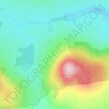
Name: Topografische Karte Kilcruaig, Höhe, Relief.
Durchschnittliche Höhe: 200 m
Minimale Höhe: 113 m
Maximale Höhe: 392 m
Andere topografische Karten
Klicken Sie auf eine Karte, um ihre Topografie, ihre Höhe und ihr Relief anzuzeigen.
Anglesborough
Ireland > County Limerick > The Municipal District of Cappamore — Kilmallock
Durchschnittliche Höhe: 229 m
Kilmallock
Ireland > County Limerick > The Municipal District of Cappamore — Kilmallock
Durchschnittliche Höhe: 89 m
Kilmurry
Ireland > County Limerick > The Municipal District of Cappamore — Kilmallock
Durchschnittliche Höhe: 90 m
Kilfinnane
Ireland > County Limerick > The Municipal District of Cappamore — Kilmallock
At an elevation of over 150 metres (500 ft), Kilfinnane is the highest town in County Limerick. It is surrounded on three sides by the Ballyhoura Mountains, and on the fourth side is the "Golden Vale" region that runs through Counties Limerick, Cork, and Tipperary.
Durchschnittliche Höhe: 160 m
Darranstown
Ireland > County Limerick > The Municipal District of Cappamore — Kilmallock
Durchschnittliche Höhe: 108 m
Ballylanders
Ireland > County Limerick > The Municipal District of Cappamore — Kilmallock
Durchschnittliche Höhe: 157 m
Knockainy
Ireland > County Limerick > The Municipal District of Cappamore — Kilmallock
Durchschnittliche Höhe: 86 m
Drombane
Ireland > County Limerick > The Municipal District of Cappamore — Kilmallock
Durchschnittliche Höhe: 50 m
Aherlow
Ireland > County Limerick > The Municipal District of Cappamore — Kilmallock
Durchschnittliche Höhe: 141 m
Clare Glens
Ireland > County Limerick > The Municipal District of Cappamore — Kilmallock
Durchschnittliche Höhe: 124 m
Glenstal
Ireland > County Limerick > The Municipal District of Cappamore — Kilmallock
Durchschnittliche Höhe: 147 m
Coolnahila (Palmer)
Ireland > County Limerick > The Municipal District of Cappamore — Kilmallock
Durchschnittliche Höhe: 39 m
Coolattin
Ireland > County Limerick > The Municipal District of Cappamore — Kilmallock
Durchschnittliche Höhe: 222 m
Caherconlish
Ireland > County Limerick > The Municipal District of Cappamore — Kilmallock
Durchschnittliche Höhe: 79 m
Coolfree
Ireland > County Limerick > The Municipal District of Cappamore — Kilmallock
Durchschnittliche Höhe: 254 m
Tobernea
Ireland > County Limerick > The Municipal District of Cappamore — Kilmallock
Durchschnittliche Höhe: 93 m
Barna
Ireland > County Limerick > The Municipal District of Cappamore — Kilmallock
Durchschnittliche Höhe: 249 m
Dromin
Ireland > County Limerick > The Municipal District of Cappamore — Kilmallock
Durchschnittliche Höhe: 73 m
Garranbane
Ireland > County Limerick > The Municipal District of Cappamore — Kilmallock
Durchschnittliche Höhe: 143 m
Ballyvalode
Ireland > County Limerick > The Municipal District of Cappamore — Kilmallock
Durchschnittliche Höhe: 66 m
Ballysallagh
Ireland > County Limerick > The Municipal District of Cappamore — Kilmallock
Durchschnittliche Höhe: 80 m
Knocknascrow
Ireland > County Limerick > The Municipal District of Cappamore — Kilmallock
Durchschnittliche Höhe: 306 m
Tullabeg
Ireland > County Limerick > The Municipal District of Cappamore — Kilmallock
Durchschnittliche Höhe: 67 m
Oola
Ireland > County Limerick > The Municipal District of Cappamore — Kilmallock
Durchschnittliche Höhe: 77 m
Nicker
Ireland > County Limerick > The Municipal District of Cappamore — Kilmallock
Durchschnittliche Höhe: 83 m
Kilmallock
Ireland > County Limerick > The Municipal District of Cappamore — Kilmallock
Durchschnittliche Höhe: 90 m
Muingacree
Ireland > County Limerick > The Municipal District of Cappamore — Kilmallock
Durchschnittliche Höhe: 268 m
Kilflynn Particles Parish Union
Ireland > County Limerick > The Municipal District of Cappamore — Kilmallock
Durchschnittliche Höhe: 211 m
Cullane South
Ireland > County Limerick > The Municipal District of Cappamore — Kilmallock
Durchschnittliche Höhe: 152 m
Toomaline Upper
Ireland > County Limerick > The Municipal District of Cappamore — Kilmallock
Durchschnittliche Höhe: 122 m
Pallasbeg
Ireland > County Limerick > The Municipal District of Cappamore — Kilmallock
Durchschnittliche Höhe: 49 m
Ballinscaula
Ireland > County Limerick > The Municipal District of Cappamore — Kilmallock
Durchschnittliche Höhe: 106 m
Ballyshoneen
Ireland > County Limerick > The Municipal District of Cappamore — Kilmallock
Durchschnittliche Höhe: 79 m
Doon South
Ireland > County Limerick > The Municipal District of Cappamore — Kilmallock
Durchschnittliche Höhe: 101 m
Anglesborough
Ireland > County Limerick > The Municipal District of Cappamore — Kilmallock
Durchschnittliche Höhe: 229 m
Doon
Ireland > County Limerick > The Municipal District of Cappamore — Kilmallock
Durchschnittliche Höhe: 112 m
Brickfield
Ireland > County Limerick > The Municipal District of Cappamore — Kilmallock
Durchschnittliche Höhe: 123 m
Mounteagle
Ireland > County Limerick > The Municipal District of Cappamore — Kilmallock
Durchschnittliche Höhe: 63 m
Dead
Ireland > County Limerick > The Municipal District of Cappamore — Kilmallock
Durchschnittliche Höhe: 62 m