
Topografische Karte Anglesborough
Klicken Sie auf die Karte, um die Höhe anzuzeigen.
Über diese Karte
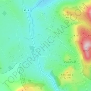
Name: Topografische Karte Anglesborough, Höhe, Relief.
Durchschnittliche Höhe: 229 m
Minimale Höhe: 145 m
Maximale Höhe: 476 m
Andere topografische Karten
Klicken Sie auf eine Karte, um ihre Topografie, ihre Höhe und ihr Relief anzuzeigen.
Bruff
Ireland > County Limerick > The Municipal District of Cappamore — Kilmallock
Durchschnittliche Höhe: 68 m
Kilcruaig
Ireland > County Limerick > The Municipal District of Cappamore — Kilmallock
Durchschnittliche Höhe: 200 m
Knockadea
Ireland > County Limerick > The Municipal District of Cappamore — Kilmallock
Durchschnittliche Höhe: 203 m
Pallasgreen
Ireland > County Limerick > The Municipal District of Cappamore — Kilmallock
Durchschnittliche Höhe: 72 m
Galtymore
Ireland > County Limerick > The Municipal District of Cappamore — Kilmallock
Galtymore or Galteemore (Irish: Cnoc Mór na nGaibhlte, meaning 'big hill of the Galtees') is a mountain in the province of Munster, Ireland. At 917.9 metres (3,011 ft 6 in), it is one of Ireland's highest mountains, being the 12th-highest on the Arderin list, and 14th-highest on the Vandeleur-Lynam list.…
Durchschnittliche Höhe: 594 m
Aherlow
Ireland > County Limerick > The Municipal District of Cappamore — Kilmallock
Durchschnittliche Höhe: 141 m
Clare Glens
Ireland > County Limerick > The Municipal District of Cappamore — Kilmallock
Durchschnittliche Höhe: 124 m
Ardpatrick
Ireland > County Limerick > The Municipal District of Cappamore — Kilmallock
Durchschnittliche Höhe: 169 m
Bruree
Ireland > County Limerick > The Municipal District of Cappamore — Kilmallock
Durchschnittliche Höhe: 62 m