
Topografische Karte Kilfinnane
Klicken Sie auf die Karte, um die Höhe anzuzeigen.
Kilfinnane
At an elevation of over 150 metres (500 ft), Kilfinnane is the highest town in County Limerick. It is surrounded on three sides by the Ballyhoura Mountains, and on the fourth side is the "Golden Vale" region that runs through Counties Limerick, Cork, and Tipperary.
Über diese Karte
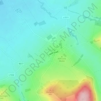
Name: Topografische Karte Kilfinnane, Höhe, Relief.
Durchschnittliche Höhe: 160 m
Minimale Höhe: 108 m
Maximale Höhe: 316 m
Andere topografische Karten
Klicken Sie auf eine Karte, um ihre Topografie, ihre Höhe und ihr Relief anzuzeigen.
Kilcruaig
Ireland > County Limerick > The Municipal District of Cappamore — Kilmallock
Durchschnittliche Höhe: 200 m
Knockadea
Ireland > County Limerick > The Municipal District of Cappamore — Kilmallock
Durchschnittliche Höhe: 203 m
Pallasgreen
Ireland > County Limerick > The Municipal District of Cappamore — Kilmallock
Durchschnittliche Höhe: 72 m
Galtymore
Ireland > County Limerick > The Municipal District of Cappamore — Kilmallock
Galtymore or Galteemore (Irish: Cnoc Mór na nGaibhlte, meaning 'big hill of the Galtees') is a mountain in the province of Munster, Ireland. At 917.9 metres (3,011 ft 6 in), it is one of Ireland's highest mountains, being the 12th-highest on the Arderin list, and 14th-highest on the Vandeleur-Lynam list.…
Durchschnittliche Höhe: 594 m
Aherlow
Ireland > County Limerick > The Municipal District of Cappamore — Kilmallock
Durchschnittliche Höhe: 141 m
Clare Glens
Ireland > County Limerick > The Municipal District of Cappamore — Kilmallock
Durchschnittliche Höhe: 124 m
Ardpatrick
Ireland > County Limerick > The Municipal District of Cappamore — Kilmallock
Durchschnittliche Höhe: 169 m
Bruff
Ireland > County Limerick > The Municipal District of Cappamore — Kilmallock
Durchschnittliche Höhe: 68 m
Bruree
Ireland > County Limerick > The Municipal District of Cappamore — Kilmallock
Durchschnittliche Höhe: 62 m