
Spenden
Topografische Karte Langley Forest
Klicken Sie auf die Karte, um die Höhe anzuzeigen.
Spenden
Über diese Karte
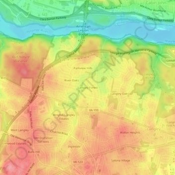
Name: Topografische Karte Langley Forest, Höhe, Relief.
Durchschnittliche Höhe: 67 m
Minimale Höhe: 9 m
Maximale Höhe: 111 m
Spenden
Andere topografische Karten
Klicken Sie auf eine Karte, um ihre Topografie, ihre Höhe und ihr Relief anzuzeigen.
McLean
United States > Virginia > Fairfax County > McLean
McLean is located at 38°56′03″N 77°10′39″W / 38.93417°N 77.17750°W / 38.93417; -77.17750 (38.9342776, −77.1774801) at an elevation of 285 feet (87 m). Located on the Capital Beltway (Interstate 495) in Northern Virginia, central McLean is 8 miles (13 km) northwest of downtown Washington,…
Durchschnittliche Höhe: 89 m
McLean
United States > Virginia > Fairfax County > McLean
McLean is located at 38°56′03″N 77°10′39″W / 38.93417°N 77.17750°W / 38.93417; -77.17750 (38.9342776, -77.1774801) at an elevation of 285 feet (87 m). Located on the Capital Beltway (Interstate 495) in Northern Virginia, central McLean is 8 miles (13 km) northwest of downtown Washington,…
Durchschnittliche Höhe: 89 m