
Topografische Karte Harsil
Klicken Sie auf die Karte, um die Höhe anzuzeigen.
Über diese Karte
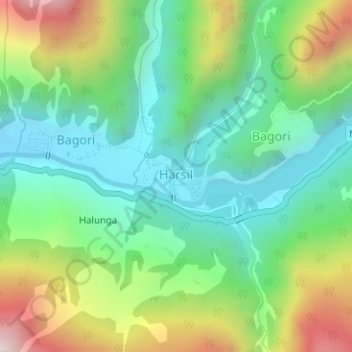
Name: Topografische Karte Harsil, Höhe, Relief.
Ort: Harsil, Bhatwari, Uttarkashi, Uttarakhand, India (31.03390 78.74709 31.03965 78.75525)
Durchschnittliche Höhe: 2.761 m
Minimale Höhe: 2.464 m
Maximale Höhe: 3.350 m
Andere topografische Karten
Klicken Sie auf eine Karte, um ihre Topografie, ihre Höhe und ihr Relief anzuzeigen.
Uttarkashi
India > Uttarakhand > Bhatwari
It is the district headquarters of Uttarkashi district. Uttarkashi is situated on the banks of river Bhagirathi at an altitude of 1158 m above sea level. Uttarkashi is generally known as a holy town close to Rishikesh. It is located in the state of Uttarakhand in India. Uttarkashi is home to a number of…
Durchschnittliche Höhe: 1.619 m
Gomukh, Ice Cave
India > Uttarakhand > Bhatwari
Around the snout, nature presents a wild topography. There are boulders scattered here and there with some pieces of broken snow, along with the hard clayey snow of the glacier.
Durchschnittliche Höhe: 4.286 m
Sudarshan Parbat
India > Uttarakhand > Bhatwari
Sudarshan Parbat is a mountain of the Garhwal Himalaya in Uttarakhand India.The elevation of Sudarshan Parbat is 6,529 metres (21,421 ft) and its prominence is 456 metres (1,496 ft). It is joint 87th highest located entirely within the Uttrakhand. Nanda Devi, is the highest mountain in this category. Sudarshan…
Durchschnittliche Höhe: 5.792 m