Geolokalisieren
👉 Easily get elevation data in JSON, GeoTIFF and KML formats using Elevation API
Vielen Dank für die Unterstützung dieser Website ❤️
Spenden

Topografische Karte Uttarkashi

Klicken Sie auf die Karte, um die Höhe anzuzeigen.

👉 Easily get elevation data in JSON, GeoTIFF and KML formats using Elevation API
Vielen Dank für die Unterstützung dieser Website ❤️
Spenden

Uttarkashi

It is the district headquarters of Uttarkashi district. Uttarkashi is situated on the banks of river Bhagirathi at an altitude of 1158 m above sea level. Uttarkashi is generally known as a holy town close to Rishikesh. It is located in the state of Uttarakhand in India. Uttarkashi is home to a number of ashrams and temples and also to the Nehru Institute of Mountaineering. The name of the town reflects its similarity to and location (as north of) the city of Kashi (Varanasi). Similar to Varanasi, town of Uttarkashi is situated on the Ganges, lies next to a hill named Varunavat, on confluence of two rivers Varuna and Asi, has a ghat called Manikarnika Ghat and has a temple dedicated to Shiva similar to (Kashi Vishwanath Temple) in Varanasi, in the center of the town.

Wikipedia (CC-BY-SA 3.0)

👉 Easily get elevation data in JSON, GeoTIFF and KML formats using Elevation API
Vielen Dank für die Unterstützung dieser Website ❤️
Spenden

Über diese Karte

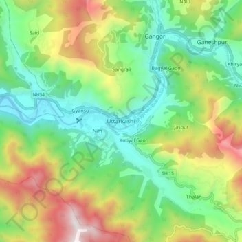
Name: Topografische Karte Uttarkashi, Höhe, Relief.

Ort: Uttarkashi, Bhatwari, Uttarkashi District, Uttarakhand, 249193, India (30.68910 78.40035 30.76910 78.48035)

Durchschnittliche Höhe: 1.619 m

Minimale Höhe: 1.052 m

Maximale Höhe: 2.642 m

👉 Easily get elevation data in JSON, GeoTIFF and KML formats using Elevation API
Vielen Dank für die Unterstützung dieser Website ❤️
Spenden

Andere topografische Karten

Klicken Sie auf eine Karte, um ihre Topografie, ihre Höhe und ihr Relief anzuzeigen.

Kyarkoti Lake

India > Uttarakhand > Bhatwari

Durchschnittliche Höhe: 4.043 m

Harsil

India > Uttarakhand > Bhatwari

Durchschnittliche Höhe: 2.761 m

Pari Maatri Taal

India > Uttarakhand > Bhatwari

Durchschnittliche Höhe: 4.443 m

Kedar Tal

India > Uttarakhand > Bhatwari

Durchschnittliche Höhe: 4.814 m

Vielen Dank für die Unterstützung dieser Website ❤️
Spenden

Harsil

India > Uttarakhand > Bhatwari

Durchschnittliche Höhe: 2.761 m

Dayara Bugyal

India > Uttarakhand > Bhatwari

Durchschnittliche Höhe: 3.451 m

Kalindi Khal Area

India > Uttarakhand > Bhatwari

Durchschnittliche Höhe: 5.857 m

Gangotri Glacier

India > Uttarakhand > Bhatwari

Durchschnittliche Höhe: 5.259 m

Vielen Dank für die Unterstützung dieser Website ❤️
Spenden

Kedar Tal

India > Uttarakhand > Bhatwari

Durchschnittliche Höhe: 4.814 m

Gangotri Glacier

India > Uttarakhand > Bhatwari

Durchschnittliche Höhe: 5.259 m