Geolokalisieren
👉 Easily get elevation data in JSON, GeoTIFF and KML formats using Elevation API
Vielen Dank für die Unterstützung dieser Website ❤️
Spenden

Topografische Karte Sudarshan Parbat

Klicken Sie auf die Karte, um die Höhe anzuzeigen.

👉 Easily get elevation data in JSON, GeoTIFF and KML formats using Elevation API
Vielen Dank für die Unterstützung dieser Website ❤️
Spenden

Sudarshan Parbat

Sudarshan Parbat is a mountain of the Garhwal Himalaya in Uttarakhand India.The elevation of Sudarshan Parbat is 6,529 metres (21,421 ft) and its prominence is 456 metres (1,496 ft). It is joint 87th highest located entirely within the Uttrakhand. Nanda Devi, is the highest mountain in this category. Sudarshan Parbat lies 2.1 km south of Chaturbhuj 6,654 metres (21,831 ft) and 3.3 km west of Shyamvarn 6,135 metres (20,128 ft). Its nearest higher neighbor Chaturbhuj. It is located 3.7 km SW of Yogeshwar 6,678 metres (21,909 ft) and 9.9 km SW lies Manda I 6,511 metres (21,362 ft).

Wikipedia (CC-BY-SA 3.0)

👉 Easily get elevation data in JSON, GeoTIFF and KML formats using Elevation API
Vielen Dank für die Unterstützung dieser Website ❤️
Spenden

Über diese Karte

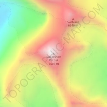
Name: Topografische Karte Sudarshan Parbat, Höhe, Relief.

Ort: Sudarshan Parbat, Bhatwari, Uttarkashi, Uttarakhand, India (30.97671 79.09398 30.97681 79.09408)

Durchschnittliche Höhe: 5.792 m

Minimale Höhe: 5.025 m

Maximale Höhe: 6.494 m

👉 Easily get elevation data in JSON, GeoTIFF and KML formats using Elevation API
Vielen Dank für die Unterstützung dieser Website ❤️
Spenden

Andere topografische Karten

Klicken Sie auf eine Karte, um ihre Topografie, ihre Höhe und ihr Relief anzuzeigen.

Kyarkoti Lake

India > Uttarakhand > Bhatwari

Durchschnittliche Höhe: 4.043 m

Harsil

India > Uttarakhand > Bhatwari

Durchschnittliche Höhe: 2.761 m

Pari Maatri Taal

India > Uttarakhand > Bhatwari

Durchschnittliche Höhe: 4.443 m

Kedar Tal

India > Uttarakhand > Bhatwari

Durchschnittliche Höhe: 4.814 m

Vielen Dank für die Unterstützung dieser Website ❤️
Spenden

Dayara Bugyal

India > Uttarakhand > Bhatwari

Durchschnittliche Höhe: 3.451 m

Gangotri Glacier

India > Uttarakhand > Bhatwari

Durchschnittliche Höhe: 5.259 m

Harsil

India > Uttarakhand > Bhatwari

Durchschnittliche Höhe: 2.761 m

Kalindi Khal Area

India > Uttarakhand > Bhatwari

Durchschnittliche Höhe: 5.857 m

Vielen Dank für die Unterstützung dieser Website ❤️
Spenden

Kedar Tal

India > Uttarakhand > Bhatwari

Durchschnittliche Höhe: 4.814 m

Gangotri Glacier

India > Uttarakhand > Bhatwari

Durchschnittliche Höhe: 5.259 m