
Topografische Karte Nabua
Klicken Sie auf die Karte, um die Höhe anzuzeigen.
Nabua
Nabua has about 8,803.0600 hectares or 99.42% very low elevation or less than 100 meters elevation and remaining 51.3593 hectares or 0.58% of low elevation or between 100 and 300 meters elevation. Its slope covers about 7,927.3616 hectares or 89.53% which are level to nearly level (0-3%) while the remaining 927.0577 hectares or 10.47% are rolling to moderately steep (18-30%)
Über diese Karte
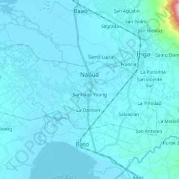
Name: Topografische Karte Nabua, Höhe, Relief.
Ort: Nabua, Camarines Sur, Bicol Region, Philippines (13.36372 123.29051 13.42938 123.42290)
Durchschnittliche Höhe: 27 m
Minimale Höhe: 2 m
Maximale Höhe: 623 m
Andere topografische Karten
Klicken Sie auf eine Karte, um ihre Topografie, ihre Höhe und ihr Relief anzuzeigen.
Calabanga
The topographic landscape of the municipality could be characterized as generally flat with a slope 0-3%, gently sloping (3-8%) towards the direction of the eastern portion and finally rolling up to higher steeps towards the direction of the south-eastern part going to Mt. Isarog. The 0-3% slope is a broad…
Durchschnittliche Höhe: 11 m
San Jose
The elevation of the municipality is roughly 92.55% low to very low with a mean elevation from 0–100 meters above sea level. Hence, low elevation is about 5.72% ranging from 100 to 300 meters above sea level as well as 1.73% with moderately high elevation ranging from 300 to 500 meters above sea level.
Durchschnittliche Höhe: 32 m
Buhi
Buhi has generally mountainous and hilly surface, with 50% of its area having a slope of around 25%. The Poblacion located on the south shore of Lake Buhi, has gently rolling topography.
Durchschnittliche Höhe: 161 m
Sipocot
Sipocot spans a total land area of approximately 218.60 square kilometers, making it one of the larger municipalities in Camarines Sur in terms of land size. Its topography is a mix of coastal plains, rolling hills, and forested uplands, with various rivers and streams contributing to the local ecosystem and…
Durchschnittliche Höhe: 61 m
Nabua
Philippines > Camarines Sur > Nabua
Nabua has about 8,803.0600 hectares or 99.42% very low elevation or less than 100 meters elevation and remaining 51.3593 hectares or 0.58% of low elevation or between 100 and 300 meters elevation. Its slope covers about 7,927.3616 hectares or 89.53% which are level to nearly level (0-3%) while the remaining…
Durchschnittliche Höhe: 14 m
Mount Isarog
Philippines > Camarines Sur > Calabanga
Mount Isarog is an active stratovolcano located in the province of Camarines Sur, Philippines, on the island of Luzon. The mountain has active fumaroles and hot springs. It has an elevation of 2,011 m (6,598 ft) above mean sea level.
Durchschnittliche Höhe: 1.565 m
Mount Isarog
Philippines > Camarines Sur > Consocep
Mount Isarog is an active stratovolcano located in the province of Camarines Sur, Philippines, on the island of Luzon. The mountain has active fumaroles and hot springs. It has an elevation of 2,011.6 m (6,600 ft) above mean sea level.
Durchschnittliche Höhe: 671 m