
Topografische Karte Sipocot
Klicken Sie auf die Karte, um die Höhe anzuzeigen.
Sipocot
Sipocot spans a total land area of approximately 218.60 square kilometers, making it one of the larger municipalities in Camarines Sur in terms of land size. Its topography is a mix of coastal plains, rolling hills, and forested uplands, with various rivers and streams contributing to the local ecosystem and agriculture. The climate is characterized by a tropical rainforest climate (Af), with substantial rainfall throughout the year, supporting a variety of crops and natural resources.
Über diese Karte
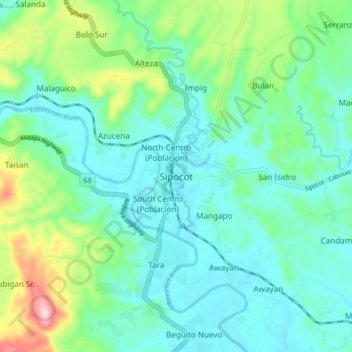
Name: Topografische Karte Sipocot, Höhe, Relief.
Ort: Sipocot, Camarines Sur, Bicol Region, 4408, Philippines (13.72664 122.93858 13.80664 123.01858)
Durchschnittliche Höhe: 61 m
Minimale Höhe: 3 m
Maximale Höhe: 252 m
Andere topografische Karten
Klicken Sie auf eine Karte, um ihre Topografie, ihre Höhe und ihr Relief anzuzeigen.
Sipocot
Sipocot spans a total land area of approximately 218.60 square kilometers, making it one of the larger municipalities in Camarines Sur in terms of land size. Its topography is a mix of coastal plains, rolling hills, and forested uplands, with various rivers and streams contributing to the local ecosystem and…
Durchschnittliche Höhe: 106 m
Nabua
Nabua has about 8,803.0600 hectares or 99.42% very low elevation or less than 100 meters elevation and remaining 51.3593 hectares or 0.58% of low elevation or between 100 and 300 meters elevation. Its slope covers about 7,927.3616 hectares or 89.53% which are level to nearly level (0-3%) while the remaining…
Durchschnittliche Höhe: 27 m
Mount Isarog
Philippines > Camarines Sur > Consocep
Mount Isarog is an active stratovolcano located in the province of Camarines Sur, Philippines, on the island of Luzon. The mountain has active fumaroles and hot springs. It has an elevation of 2,011.6 m (6,600 ft) above mean sea level.
Durchschnittliche Höhe: 671 m
Sipocot
Sipocot spans a total land area of approximately 218.60 square kilometers, making it one of the larger municipalities in Camarines Sur in terms of land size. Its topography is a mix of coastal plains, rolling hills, and forested uplands, with various rivers and streams contributing to the local ecosystem and…
Durchschnittliche Höhe: 106 m
Buhi
Buhi has generally mountainous and hilly surface, with 50% of its area having a slope of around 25%. The Poblacion located on the south shore of Lake Buhi, has gently rolling topography.
Durchschnittliche Höhe: 304 m
Sipocot
Sipocot spans a total land area of approximately 218.60 square kilometers, making it one of the larger municipalities in Camarines Sur in terms of land size. Its topography is a mix of coastal plains, rolling hills, and forested uplands, with various rivers and streams contributing to the local ecosystem and…
Durchschnittliche Höhe: 106 m