
Topografische Karte Catanduanes Island
Interaktive Karte
Klicken Sie auf die Karte, um die Höhe anzuzeigen.
Über diese Karte
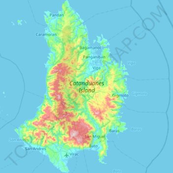
Name: Topografische Karte Catanduanes Island, Höhe, Relief.
Ort: Catanduanes Island, Catanduanes, Bicol Region, Philippines (13.51666 124.02361 14.09864 124.42182)
Durchschnittliche Höhe: 73 m
Minimale Höhe: -2 m
Maximale Höhe: 797 m
Andere topografische Karten
Klicken Sie auf eine Karte, um ihre Topografie, ihre Höhe und ihr Relief anzuzeigen.
Virac
Virac, Catanduanes, Bicol Region, 4800, Philippines
Durchschnittliche Höhe: 95 m
Paraiso
Paraiso, Catanduanes, Bicol Region, Philippines
Durchschnittliche Höhe: 200 m
Panay Island
Philippines > Catanduanes > Quigaray
Panay Island, Quigaray, Catanduanes, Bicol Region, Philippines
Durchschnittliche Höhe: 15 m
Sapang Palay
Philippines > Catanduanes > Sapang Palay
Sapang Palay, Catanduanes, Bicol Region, 4810, Philippines
Durchschnittliche Höhe: 28 m
Boton
Philippines > Catanduanes > Boton
Boton, Catanduanes, Bicol Region, Philippines
Durchschnittliche Höhe: 141 m
Buhi
Philippines > Catanduanes > Buhi
Buhi, Catanduanes, Bicol Region, Philippines
Durchschnittliche Höhe: 159 m