
Vielen Dank für die Unterstützung dieser Website ❤️
Spenden
Spenden
Topografische Karte Virac
Klicken Sie auf die Karte, um die Höhe anzuzeigen.
Vielen Dank für die Unterstützung dieser Website ❤️
Spenden
Spenden
Über diese Karte
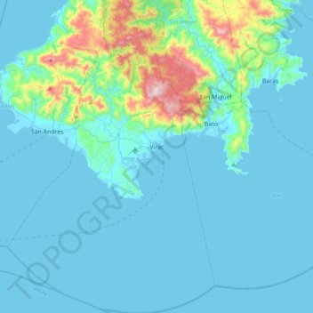
Name: Topografische Karte Virac, Höhe, Relief.
Ort: Virac, Catanduanes, Bicol Region, 4800, Philippines (13.38177 124.04811 13.75477 124.30270)
Durchschnittliche Höhe: 95 m
Minimale Höhe: -2 m
Maximale Höhe: 799 m
Vielen Dank für die Unterstützung dieser Website ❤️
Spenden
Spenden
Andere topografische Karten
Klicken Sie auf eine Karte, um ihre Topografie, ihre Höhe und ihr Relief anzuzeigen.