
Topografische Karte Inner Mongolia
Interaktive Karte
Klicken Sie auf die Karte, um die Höhe anzuzeigen.
Über diese Karte
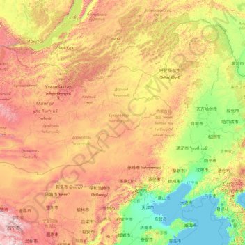
Name: Topografische Karte Inner Mongolia, Höhe, Relief.
Ort: Inner Mongolia, China (37.40671 97.22502 53.33406 125.32729)
Durchschnittliche Höhe: 891 m
Minimale Höhe: -2 m
Maximale Höhe: 4.757 m
Inner Mongolia largely consists of the northern side of the North China Craton, a tilted and sedimented Precambrian block. In the extreme southwest is the edge of the Tibetan Plateau where the autonomous region's highest peak, Main Peak in the Helan Mountains reaches 3,556 metres (11,670 ft), and is still being pushed up today in short bursts. Most of Inner Mongolia is a plateau averaging around 1,200 metres (3,940 ft) in altitude and covered by extensive loess and sand deposits. The northern part consists of the Mesozoic era Khingan Mountains, and is owing to the cooler climate more forested, chiefly with Manchurian elm, ash, birch, Mongolian oak and a number of pine and spruce species. Where discontinuous permafrost is present north of Hailar District, forests are almost exclusively coniferous. In the south, the natural vegetation is grassland in the east and very sparse in the arid west, and grazing is the dominant economic activity.
Andere topografische Karten
Klicken Sie auf eine Karte, um ihre Topografie, ihre Höhe und ihr Relief anzuzeigen.
Yingjiang County
China > Yunnan > Yingjiang County
Yingjiang County, Dehong, Yunnan, 665000, China
Durchschnittliche Höhe: 1.428 m
Hezuo
China > Gansu > Hezuo City
Hezuo, Hezuo City, Gannan, Gansu, 747000, China
Durchschnittliche Höhe: 3.199 m
Nuozhadu Dam
China > Yunnan > Lancang Lahu Autonomous County
Nuozhadu Dam, Lancang Lahu Autonomous County, Pu'er City, Yunnan, China
Durchschnittliche Höhe: 843 m
Qanag
China > Tibet > Mainling City
Qanag, Mainling City, Nyingchi Prefecture, Tibet, China
Durchschnittliche Höhe: 3.790 m
Xin'anjiang Hydropower Station
China > Zhejiang > Jiande > 滩头坞
Xin'anjiang Hydropower Station, 滩头坞, Jiande, Zhejiang, China
Durchschnittliche Höhe: 158 m
Simao District
Simao District, Pu'er City, Yunnan, China
Durchschnittliche Höhe: 1.263 m
Tarim Basin
China > Xinjiang > Qarqan County > Tazhong Town
Tarim Basin, Tazhong Town, Qarqan County, Bayingolin, Xinjiang, China
Durchschnittliche Höhe: 1.055 m
Yellow River
China > Gansu > Maqu County > Gaoyuan Institute of Biology
Yellow River, Gaoyuan Institute of Biology, Maqu County, Gannan, Gansu, China
Durchschnittliche Höhe: 3.505 m
Taiping District
Taiping District, Fuxin City, Liaoning, 123000, China
Durchschnittliche Höhe: 235 m
Xi'nanci
China > Beijing > Daxing District
Xi'nanci, Daxing District, Beijing, China
Durchschnittliche Höhe: 34 m
Yangtougang
China > Beijing > Fangshan District
Yangtougang, Fangshan District, Beijing, 102400, China
Durchschnittliche Höhe: 61 m
Dali Bai Autonomous Prefecture
Dali Bai Autonomous Prefecture, Yunnan, China
Durchschnittliche Höhe: 2.168 m
Heihe
China > Heilongjiang > 幸福乡
Heihe, 幸福乡, Aihui District, Heihe City, Heilongjiang, 164300, China
Durchschnittliche Höhe: 174 m
Apengjiang
Apengjiang, Qianjiang District, Chongqing, China
Durchschnittliche Höhe: 852 m
Tianshan District
Tianshan District, Ürümqi, Xinjiang, 830000, China
Durchschnittliche Höhe: 1.108 m
Qingyang District
Qingyang District, Chengdu, Sichuan, China
Durchschnittliche Höhe: 510 m
Bangshan
China > Fujian > Longhai District
Bangshan, Longhai District, Zhangzhou City, Fujian, China
Durchschnittliche Höhe: 37 m
Haixi Mongol and Tibetan Autonomous Prefecture
Haixi Mongol and Tibetan Autonomous Prefecture, Qinghai, China
Durchschnittliche Höhe: 3.739 m
Zhongshan
China > Guangxi > Zhongshan County
Zhongshan, Zhongshan County, Hezhou, Guangxi, China
Durchschnittliche Höhe: 246 m