
Topografische Karte Hezuo
Interaktive Karte
Klicken Sie auf die Karte, um die Höhe anzuzeigen.
Über diese Karte
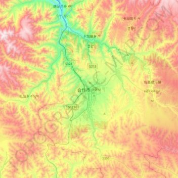
Name: Topografische Karte Hezuo, Höhe, Relief.
Ort: Hezuo, Hezuo City, Gannan, Gansu, 747000, China (34.84140 102.74827 35.16140 103.06827)
Durchschnittliche Höhe: 3.199 m
Minimale Höhe: 2.609 m
Maximale Höhe: 3.833 m
With an elevation of nearly 3,000 metres (9,800 ft), Hezuo has an alpine subarctic climate (Köppen Dwc), with long, very cold, dry winters, and short, mild summers. The monthly daily mean temperature in January, the coldest month, is −9.3 °C (15.3 °F), while the same figure for July, the warmest month, is 13.3 °C (55.9 °F); the annual mean is 2.82 °C (37.1 °F). Most of the annual precipitation is delivered from May to September. With monthly percent possible sunshine ranging from 44% in June and September to 71% in December, the city receives 2,370 hours of bright sunshine annually.