
Topografische Karte South Rimo Glacier
Klicken Sie auf die Karte, um die Höhe anzuzeigen.
Über diese Karte
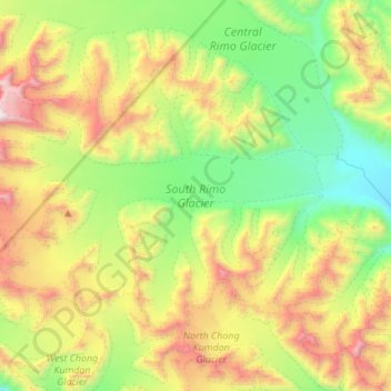
Name: Topografische Karte South Rimo Glacier, Höhe, Relief.
Ort: South Rimo Glacier, India (35.25208 77.36310 35.40649 77.60807)
Durchschnittliche Höhe: 5.588 m
Minimale Höhe: 4.867 m
Maximale Höhe: 6.588 m
Andere topografische Karten
Klicken Sie auf eine Karte, um ihre Topografie, ihre Höhe und ihr Relief anzuzeigen.
Bengaluru
India > Karnataka > Bangalore North
Bengaluru (formerly Bangalore) is situated in the southeastern part of Karnataka, India, within the Bengaluru Urban district. It lies at an elevation of approximately 900 meters (3,000 feet) above sea level, on the Deccan Plateau. This elevated position gives the city a moderate climate, with temperatures…
Durchschnittliche Höhe: 881 m
Chennai
Chennai is located on the southeastern coast of India in the northeastern part of Tamil Nadu on a flat coastal plain known as the Eastern Coastal Plains with an average elevation of 6.7 m (22 ft) and highest point at 60 m (200 ft). Chennai's soil is mostly clay, shale and sandstone. Clay underlies most of the…
Durchschnittliche Höhe: 8 m
Mumbai
India > Maharashtra > Mumbai
Mumbai is on a narrow peninsula on the southwest of Salsette Island, which lies between the Arabian Sea to the west, Thane Creek to the east and Vasai Creek to the north. Mumbai's suburban district occupies most of the island. Navi Mumbai is east of Thane Creek and Thane is north of Vasai Creek. Mumbai…
Durchschnittliche Höhe: 18 m
Surat
India > Gujarat > Katargam Taluka > Surat
Surat is a port city situated on the banks of the Tapi river. Damming of the Tapi caused the original port facilities to close; the nearest port is now in the Magadalla and Hazira area of Surat Metropolitan Region.It has famous beach called 'Dumas Beach' located in Hazira. The city is located at 21°10′N…
Durchschnittliche Höhe: 11 m
Vadodara
India > Gujarat > Vadodara Rural Taluka
Vadodara is located at 22°18′N 73°11′E / 22.30°N 73.19°E / 22.30; 73.19 in western India at an elevation of 39 metres (128 ft). It is the tenth-largest city in India with an area of 400 square kilometres (150 sq mi) and a population of 3.5 million, according to the 2010–11 census. The city…
Durchschnittliche Höhe: 36 m
Chennai
Chennai is located on the southeastern coast of India in the northeastern part of Tamil Nadu on a flat coastal plain known as the Eastern Coastal Plains with an average elevation of 6.7 m (22 ft) and highest point at 60 m (200 ft). Chennai's soil is mostly clay, shale and sandstone. Clay underlies most of the…
Durchschnittliche Höhe: 8 m
Tamil Nadu
The annual rainfall of the state is about 945 mm (37.2 in) of which 48 per cent is through the northeast monsoon, and 32 per cent through the southwest monsoon. Since the state is entirely dependent on rains for recharging its water resources, monsoon failures lead to acute water scarcity and severe drought.…
Durchschnittliche Höhe: 253 m
Hyderabad
India > Telangana > Bahadurpura mandal
Hyderabad (/ˈhaɪdərəbæd/ HY-dər-ə-bad; Telugu: [ˈɦaɪ̯daraːbaːd], Urdu: [ˈɦɛːdəɾaːbaːd]) is the capital and largest city of the Indian state of Telangana. It occupies 650 km2 (250 sq mi) on the Deccan Plateau along the banks of the Musi River, in the northern part of Southern India. With an…
Durchschnittliche Höhe: 549 m
Haryana
Haryana is a landlocked state in northern India. It is between 27°39' to 30°35' N latitude and between 74°28' and 77°36' E longitude. The total geographical area of the state is 4.42 m ha, which is 1.4% of the geographical area of the country. The altitude of Haryana varies between 700 and 3600 ft (200…
Durchschnittliche Höhe: 281 m
Maharashtra
Maharashtra is the third largest state by area in India. The Western Ghats better known as Sahyadri, are a hilly range running parallel to the coast, at an average elevation of 1,200 metres (4,000 ft). Kalsubai, a peak in the Sahyadris, near Nashik city is the highest elevated point in Maharashtra. To the west…
Durchschnittliche Höhe: 478 m
Maharashtra
Maharashtra with a total area of 307,713 km2 (118,809 sq mi), is the third-largest state by area in terms of land area and constitutes 9.36 per cent of India's total geographical area. The State lies between 15°35' N to 22°02' N latitude and 72°36' E to 80°54' E longitude. It occupies the western and…
Durchschnittliche Höhe: 346 m
Chennai
Chennai district covers an area of 426 km2 located on the Eastern Coastal Plains of India. It is situated on the northeastern corner of Tamil Nadu along the Coramandel coast, a region bounded by the Bay of Bengal and is surrounded inland by the districts of Tiruvallur, Kanchipuram and Chengalpattu. It lies…
Durchschnittliche Höhe: 12 m
Thiruvananthapuram
India > Kerala > Thiruvananthapuram
Thiruvananthapuram is built on seven hills by the seashore and is at 8°30′N 76°54′E / 8.5°N 76.9°E / 8.5; 76.9 on the west coast, near the southern tip of mainland India. The city is on the west coast of India and is bounded by the Laccadive Sea to its west and the Western Ghats to its east.…
Durchschnittliche Höhe: 33 m
Maharashtra
Maharashtra with a total area of 307,713 km2 (118,809 sq mi), is the third-largest state by area in terms of land area and constitutes 9.36 per cent of India's total geographical area. The State lies between 15°35' N to 22°02' N latitude and 72°36' E to 80°54' E longitude. It occupies the western and…
Durchschnittliche Höhe: 346 m
Srinagar
India > Jammu and Kashmir > Srinagar (South)
Under the Köppen climate classification, Srinagar has a four-season humid subtropical climate (Cfa) with hot summers and cool winters. The valley is surrounded by the Himalayas on all sides. Due to influence from Himalayan rain shadow and western disturbances, Srinagar has year-round precipitation; the spring…
Durchschnittliche Höhe: 1.805 m
Bengaluru
India > Karnataka > Bangalore North
Bengaluru (formerly Bangalore) is situated in the southeastern part of Karnataka, India, within the Bengaluru Urban district. It lies at an elevation of approximately 900 meters (3,000 feet) above sea level, on the Deccan Plateau. This elevated position gives the city a moderate climate, with temperatures…
Durchschnittliche Höhe: 881 m
Tamil Nadu
The annual rainfall of the state is about 945 mm (37.2 in) of which 48 per cent is through the northeast monsoon, and 32 per cent through the southwest monsoon. Since the state is entirely dependent on rains for recharging its water resources, monsoon failures lead to acute water scarcity and severe drought.…
Durchschnittliche Höhe: 253 m
Goa
Goa is a part of the coastal country known as the Konkan, which is an escarpment rising up to the Western Ghats range of mountains, which separate it from the Deccan Plateau. The highest point is the Sonsogor Peak, with an altitude of 1,026 m (3,366 ft). Goa has a coastline of 160 km (99 mi).
Durchschnittliche Höhe: 228 m
Pune
Pune is situated at approximately 18° 32" north latitude and 73° 51" east longitude. The area of Pune district is 15,642 km2, and the municipal corporation area covers 518 km2. By road Pune is 149 km (93 mi) south-east of Mumbai, 580 km (360 mi) south-west of Indore, 695 km (432 mi) west of Nagpur, 1,173 km…
Durchschnittliche Höhe: 616 m
Karnataka
The bulk of the state is in the Bayaluseeme region, the northern part of which is the second-largest arid region in India. The highest point in Karnataka is the Mullayanagiri hills in Chikmagalur district which has an altitude of 1,925 metres (6,316 ft). The two main river systems of the state are the Krishna…
Durchschnittliche Höhe: 386 m
Kerala
Kerala was alternatively called Malabar in the foreign trade circles. Earlier, the term Malabar had also been used to denote Tulu Nadu and Kanyakumari which lie contiguous to Kerala on the southwestern coast of India, in addition to the modern state of Kerala. The people of Malabar were known as Malabars.…
Durchschnittliche Höhe: 251 m
Jammu and Kashmir
Jammu and Kashmir is home to several valleys such as the Kashmir Valley, Tawi Valley, Chenab Valley, Poonch Valley, Sind Valley, and Lidder Valley. The Kashmir valley is 100 km (62 mi) wide and 15,520.3 km2 (5,992.4 sq mi) in area. The Himalayas divide the Kashmir valley from the Tibetan plateau while the Pir…
Durchschnittliche Höhe: 2.430 m
Nagaland
Nagaland lies between 93°20'E and 95°15'E longitude and between 25°6'N and 27°4'N latitude. It is largely a mountainous state. The Naga Hills rise from the Brahmaputra Valley in Assam to about 610 metres (2,000 ft) and rise further to the southeast, as high as 1,800 metres (6,000 ft). Mount Saramati at an…
Durchschnittliche Höhe: 824 m
Chamoli
The geology of the region shows that the Himalayas are amongst the youngest mountains in the world. During early Mesozoic times the land mass now covered by them was occupied by the great Tethys sea. The probable date of the commencement of the elevation of the Himalayas is about the close of the Mesozoic era,…
Durchschnittliche Höhe: 3.712 m
Rajkot
India > Gujarat > Rajkot East Taluka
Rajkot is located at 22°18′N 70°47′E / 22.3°N 70.78°E / 22.3; 70.78. It has an average elevation of 128 metres (420 ft). The city is located on the bank of Aji River and Nyari River which remains dry except the monsoon months of July to September. The city is spread in the area of 170.00 km².
Durchschnittliche Höhe: 141 m
Bihar
Bihar covers a total area of 94,163 km2 (36,357 sq mi), with an average elevation above sea level of 173 feet (53 m). It is land locked by Nepal in the north, Jharkhand in the south West Bengal in the east and Uttar Pradesh to the west. It has three parts on the basis of physical and structural conditions: the…
Durchschnittliche Höhe: 605 m
Madhya Pradesh
Madhya Pradesh literally means "Central Province", and is located in the geographic heart of India in between the latitude of 21.6°N–26.30°N and longitude of 74°9'E–82°48'E. The state straddles the Narmada River, which runs east and west between the Vindhya and Satpura ranges; these ranges and the…
Durchschnittliche Höhe: 347 m
Chennai
Chennai is located on the south–eastern coast of India in the north–eastern part of Tamil Nadu on a flat coastal plain known as the Eastern Coastal Plains. Its average elevation is around 6.7 metres (22 ft), and its highest point is 60 m (200 ft). Chennai is 2,184 kilometres (1,357 mi) south of Delhi,…
Durchschnittliche Höhe: 7 m
Kanniyakumari
Kanyakumari district has a varied topography with sea on three sides and the mountains of the Western Ghats bordering the northern side. Except for a small stretch of land to the west of Kanyakumari town, almost the entire district is sandwiched between the Western Ghats and the Arabian Sea - the only district…
Durchschnittliche Höhe: 226 m
West Bengal
The distribution of vegetation in northern West Bengal is dictated by elevation and precipitation. For example, the foothills of the Himalayas, the Dooars, are densely wooded with sal and other tropical evergreen trees. Above an elevation of 1,000 metres (3,300 ft), the forest becomes predominantly…
Durchschnittliche Höhe: 182 m
Guwahati
Professor Abani Kumar Bhagawati of Gauhati University stated that since before there were sufficient wetlands to absorb rainwater and channels to carry excess water to the Brahmaputra, the city did not experience floods. However, human interference has disrupted the natural topography, leading to the current…
Durchschnittliche Höhe: 113 m
Surat
India > Gujarat > Katargam Taluka
Surat is a port city situated on the banks of the Tapi river. After dams were built, water flow in Tapi deceased causing the original port facilities to close. The nearest port is now in the Magadalla and Hazira area of Surat Metropolitan Region. It has a famous beach called 'Dumas Beach' located in Dumas.The…
Durchschnittliche Höhe: 13 m
Kirandul
India > Chhattisgarh > Kuakonda Tahsil
The Kothavalasa–Kirandul line of East Coast Railway from Kirandul to Visakhapatnam via Koraput is laid through the Eastern Ghats. Up to Araku station, it has many tunnels. Also it pass through the highest elevation Broad gauge station in the Eastern ghats, Semiliguda, just before the Borra caves. Kirandul -…
Durchschnittliche Höhe: 742 m
Thiruvananthapuram
India > Kerala > Thiruvananthapuram
Thiruvananthapuram is built on seven hills by the seashore and is at 8°30′N 76°54′E / 8.5°N 76.9°E / 8.5; 76.9 on the west coast, near the southern tip of mainland India. The city is on the west coast of India and is bounded by the Laccadive Sea to its west and the Western Ghats to its east.…
Durchschnittliche Höhe: 33 m
Rajasthan
The Aravalli Range runs across the state from the southwest peak Guru Shikhar (Mount Abu), which is 1,722 metres (5,650 ft) in height, to Khetri in the northeast. This range divides the state into 60% in the northwest of the range and 40% in the southeast. The northwest tract is sandy and unproductive with…
Durchschnittliche Höhe: 254 m
Visakhapatnam
India > Andhra Pradesh > Visakhapatnam Urban
The city is situated between the Eastern Ghats and the Bay of Bengal. The city coordinates lies between 17.7041 N and 83.2977 E. The city's area is 682 km2. The average elevation is 45 metres. Visakhpatnam is situated in Coastal Andhra Region.
Durchschnittliche Höhe: 35 m
Uttar Pradesh
Uttar Pradesh, with a total area of 243,290 square kilometres (93,935 sq mi), is India's fourth-largest state in terms of land area and is roughly of same size as United Kingdom. It is situated on the northern spout of India and shares an international boundary with Nepal. The Himalayas border the state on the…
Durchschnittliche Höhe: 954 m
Kerala
Kerala was alternatively called Malabar in the foreign trade circles. Earlier, the term Malabar had also been used to denote Tulu Nadu and Kanyakumari which lie contiguous to Kerala on the southwestern coast of India, in addition to the modern state of Kerala. The people of Malabar were known as Malabars.…
Durchschnittliche Höhe: 251 m
Kalahandi
Kalahandi lies between 19.3 N and 21.5 N latitudes and 82.20 E and 83.47 E longitudes in southwestern Odisha, bordered to the north by the Balangir district and Nuapada district, to the south by the Nabarangpur district, Koraput district and Rayagada district, and to the east by the Rayagada district,…
Durchschnittliche Höhe: 426 m
Pali
The Aravalli Range forms the eastern boundary of the district, and the southern boundary ends at Bamnera village in Sumerpur Tehsil. There are foothills to the west, through which run some Luni River tributaries. The western portion of the district includes the alluvial plain of the Luni. The district is…
Durchschnittliche Höhe: 377 m