
Spenden
Topografische Karte Manipur
Klicken Sie auf die Karte, um die Höhe anzuzeigen.
Spenden
Manipur
The state lies at a latitude of 23°83'N – 25°68'N and a longitude of 93°03'E – 94°78'E. The total area covered by the state is 22,327 square kilometres (8,621 sq mi). The capital lies in an oval-shaped valley of approximately 700 square miles (2,000 km2), surrounded by blue mountains, at an elevation of 790 metres (2,590 ft) above sea level. The slope of the valley is from north to south. The mountain ranges create a moderated climate, preventing the cold winds from the north from reaching the valley and barring cyclonic storms.
Spenden
Über diese Karte
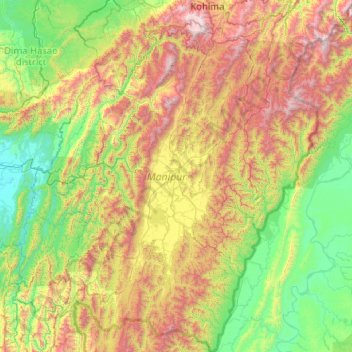
Name: Topografische Karte Manipur, Höhe, Relief.
Ort: Manipur, India (23.83362 92.97071 25.69210 94.74524)
Durchschnittliche Höhe: 810 m
Minimale Höhe: 19 m
Maximale Höhe: 2.997 m
Spenden
Andere topografische Karten
Klicken Sie auf eine Karte, um ihre Topografie, ihre Höhe und ihr Relief anzuzeigen.
Mangaluru
India > Karnataka > Mangaluru taluk
Mangalore is also the administrative headquarters of the Dakshina Kannada district; it is a commercial, industrial, educational, healthcare, and startup hub. The city's international airport is the second-largest and second-busiest airport in Karnataka. Mangalore City Corporation is responsible for the civic…
Durchschnittliche Höhe: 25 m
Dehradun
India > Uttarakhand > Dehradun
The city of Dehradun mainly lies in Doon Valley and is at a varying height from 410 m (1,350 ft) in Clement Town to above 700 m (2,300 ft) at Malsi which is 15 km (9.3 mi) from the city. However, the average elevation is 450 m (1,480 ft) above sea level. Malsi is the starting point of Lesser Himalayan Range…
Durchschnittliche Höhe: 904 m
Spenden
Maharashtra
Maharashtra is the third largest state by area in India. The Western Ghats better known as Sahyadri, are a hilly range running parallel to the coast, at an average elevation of 1,200 metres (4,000 ft). Kalsubai, a peak in the Sahyadris, near Nashik city is the highest elevated point in Maharashtra. To the west…
Durchschnittliche Höhe: 478 m
Visakhapatnam
India > Andhra Pradesh > Visakhapatnam (Urban)
The city is situated between the Eastern Ghats and the Bay of Bengal. The city coordinates lies between 17.7041 N and 83.2977 E. The city's area is 682 km2. The average elevation is 45 metres. Visakhpatnam is situated in Coastal Andhra Region.
Durchschnittliche Höhe: 35 m
Spenden
Dharamshala
India > Himachal Pradesh > Dharamshala
Dharamshala has an average elevation of 1,457 m (4,780 ft), covering an area of almost 8.51 km2 (3.29 sq mi). Dharamsala is located in the Kangra Valley, in the shadow of the Dhauladhar mountains.
Durchschnittliche Höhe: 1.781 m
Kolkata
Spread roughly north–south along the east bank of the Hooghly River, Kolkata sits within the lower Ganges Delta of eastern India approximately 75 km (47 mi) west of the international border with Bangladesh; the city's elevation is 1.5–9 m (5–30 ft). Much of the city was originally a wetland that was…
Durchschnittliche Höhe: 5 m
Spenden
Mumbai
Mumbai lies at the mouth of the Ulhas River on the western coast of India, in the coastal region known as the Konkan. It sits on Salsette Island (Sashti Island), which it partially shares with the Thane district. Mumbai is bounded by the Arabian Sea to the west. Many parts of the city lie just above sea level,…
Durchschnittliche Höhe: 13 m
Chincholi
India > Karnataka > Chincholi taluku
Chincholi is located at 17°28′N 77°26′E / 17.47°N 77.43°E / 17.47; 77.43. It has an average elevation of 462 m (1,516 ft). The town is spread over an area of 6 km2 (2.3 sq mi).
Durchschnittliche Höhe: 466 m
Solan
India > Himachal Pradesh > Solan
Solan is a city in the Indian state of Himachal Pradesh and the district headquarters of Solan district. It is located 45.5 kilometres (28 mi) south of the state capital, Shimla. Solan has an average elevation of 1,550 metres (5,090 ft). The city is situated between Chandigarh (joint capital of Punjab and…
Durchschnittliche Höhe: 1.312 m
Kaveripattinam
India > Tamil Nadu > Krishnagiri
Kaveripattinam is located at 12°25′N 78°14′E / 12.42°N 78.23°E / 12.42; 78.23 on the NH 44, a major north–south National Highway, one of the longest and busiest road in the country. It has an average elevation of 533 metres (1,749 ft). This town has a cool climate. It lies on the bank of the…
Durchschnittliche Höhe: 462 m
Spenden
Spenden
Shimla
Shimla is on the south-western ranges of the Himalayas at 31°37′N 77°06′E / 31.61°N 77.10°E / 31.61; 77.10. It has an average altitude of 2,206 metres (7,238 ft) above mean sea level and extends along a ridge with seven spurs. The city stretches nearly 9.2 kilometres (5.7 mi) from east to west.
Durchschnittliche Höhe: 1.557 m
Manipal
India > Karnataka > Udupi taluku
Manipal is a suburb and university town within Udupi, in coastal Karnataka, India. Manipal is located five kilometres away from the centre of Udupi City, in Udupi District, Karnataka (state) in south western India. It is administered by the Udupi City Municipality. The suburb is located in coastal Karnataka,…
Durchschnittliche Höhe: 32 m
Thiruvananthapuram
India > Kerala > Thiruvananthapuram
Thiruvananthapuram is built on seven hills by the seashore and is at 8°30′N 76°54′E / 8.5°N 76.9°E / 8.5; 76.9 on the west coast, near the southern tip of mainland India. The city is on the west coast of India and is bounded by the Laccadive Sea to its west and the Western Ghats to its east.…
Durchschnittliche Höhe: 33 m
Spenden
Roorkee
India > Uttarakhand > Roorkee
Roorkee is located at 29°52′N 77°53′E / 29.87°N 77.88°E / 29.87; 77.88. It has an average elevation of 268 metres (879 ft).
Durchschnittliche Höhe: 270 m
Spenden
Mussoorie
India > Uttarakhand > Dehradun
Mussoorie is at an average altitude of 2,005 metres (6,578 ft). To the northeast are the Himalayan snow ranges, and to the south, the Doon Valley and Shiwalik ranges. The second highest point is the original Lal Tibba in Landour, with a height of over 2,275 m (7,464 ft). Mussoorie is popularly known as The…
Durchschnittliche Höhe: 1.594 m
Bhopal
India > Madhya Pradesh > Huzur Tahsil
Bhopal has an average elevation of 500 metres (1401 ft) and is located in the central part of India, just north of the upper limit of the Vindhya mountain ranges. Located on the Malwa plateau, it is higher than the north Indian plains and the land rises towards the Vindhya Range to the south. The city has…
Durchschnittliche Höhe: 498 m
Spenden
Spenden
Spenden
Spenden
Spenden
Chennai
Chennai is located on the south–eastern coast of India in the north–eastern part of Tamil Nadu on a flat coastal plain known as the Eastern Coastal Plains. Its average elevation is around 6.7 metres (22 ft), and its highest point is 60 m (200 ft). Chennai is 2,184 kilometres (1,357 mi) south of Delhi,…
Durchschnittliche Höhe: 7 m
Spenden
Leh
Leh (/ˈlɛ/) (Ladakhi: གླེ) is the joint capital and largest city of Ladakh, a union territory of India. Leh, located in the Leh district, was also the historical capital of the Kingdom of Ladakh, the seat of which was in the Leh Palace, the former residence of the royal family of Ladakh, built in the…
Durchschnittliche Höhe: 4.294 m
Digha
India > West Bengal > Digha
Digha is located at 21°38′18″N 87°30′35″E / 21.6384°N 87.5096°E / 21.6384; 87.5096. It has an average elevation of 6 metres (20 ft).
Durchschnittliche Höhe: 4 m
Spenden
Ranchi
Ranchi lies at 23°22′N 85°20′E / 23.36°N 85.33°E / 23.36; 85.33 near to the Tropic of Cancer. The city covers an area of 175 km2 (68 sq mi) and its average elevation is 651 m above sea level. Ranchi is located in the southern part of the Chota Nagpur plateau, which is the eastern section of…
Durchschnittliche Höhe: 648 m
Indore
India > Madhya Pradesh > Juni Indore Tahsil
Indore /ɪnˈdɔːr/ (listen) is the most populous and the largest city in the Indian state of Madhya Pradesh. It serves as the headquarters of both Indore District and Indore Division. It is also considered as an education hub of the state and has campuses of both the Indian Institute of Technology and the…
Durchschnittliche Höhe: 555 m
Guwahati
Professor Abani Kumar Bhagawati of Gauhati University stated that since before there were sufficient wetlands to absorb rainwater and channels to carry excess water to the Brahmaputra, the city did not experience floods. However, human interference has disrupted the natural topography, leading to the current…
Durchschnittliche Höhe: 113 m
Spenden
Salem
Salem is located at 11°40′N 78°08′E / 11.67°N 78.14°E / 11.67; 78.14, at an average elevation of 278 m (912 ft). The city is surrounded by hills: Nagaramalai on the north, Jarugumalai on the south, Kanjamalai on the west, Godumalai on the east and the Shevaroy Hills on the northeast.…
Durchschnittliche Höhe: 418 m
Spenden
Mumbai
Mumbai lies at the mouth of the Ulhas River on the western coast of India, in the coastal region known as the Konkan. It sits on Salsette Island (Sashti Island), which it partially shares with the Thane district. Mumbai is bounded by the Arabian Sea to the west. Many parts of the city lie just above sea level,…
Durchschnittliche Höhe: 13 m
Spenden
Mashobra
India > Himachal Pradesh > Shimla (urban)
Mashobra is located at 31°08′N 77°14′E / 31.13°N 77.23°E / 31.13; 77.23. It has an average elevation of 2,146 metres (7,041 feet).
Durchschnittliche Höhe: 1.938 m
Spenden
Anakapalle
India > Andhra Pradesh > Anakapalle
Anakapalli is located at 17°41′29″N 83°00′14″E / 17.6913°N 83.0039°E / 17.6913; 83.0039, on the banks of River Sarada and at an altitude of 29 m (95 ft). It is spread over an area of 23.28 km2 (8.99 sq mi).
Durchschnittliche Höhe: 35 m
Spenden
Spenden
Erattupetta
It has an average elevation of 36 metres (118 feet).
Durchschnittliche Höhe: 78 m
Spenden
Spenden
Ernakulam
India > Kerala > Kanayannur
The Ernakulam District is situated in Central Kerala in India. Ernakulam is located at 9°59′N 76°17′E / 9.98°N 76.28°E / 9.98; 76.28. It has an average elevation of 4 m (13 ft).
Durchschnittliche Höhe: 6 m
Spenden
Tirunelveli
India > Tamil Nadu > Palayamkottai
Tirunelveli is located at 8°43′41.82″N 77°41′43.94″E / 8.7282833°N 77.6955389°E / 8.7282833; 77.6955389, and its average elevation is 47 metres (154 ft). It is located at the southernmost tip of the Deccan plateau. The Tamirabarani River divides the city into the Tirunelveli quarter and…
Durchschnittliche Höhe: 34 m
Spenden
Spenden