
Spenden
Topografische Karte Lamont
Klicken Sie auf die Karte, um die Höhe anzuzeigen.
Spenden
Über diese Karte
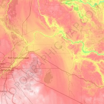
Name: Topografische Karte Lamont, Höhe, Relief.
Ort: Lamont, Alberta, Canada (53.08345 -113.14781 54.48345 -111.74781)
Durchschnittliche Höhe: 670 m
Minimale Höhe: 527 m
Maximale Höhe: 806 m
Spenden
Andere topografische Karten
Klicken Sie auf eine Karte, um ihre Topografie, ihre Höhe und ihr Relief anzuzeigen.
Lac Ste. Anne
Canada > Alberta > Lac Ste. Anne County > Village of Alberta Beach
The lake has a total area of 54.5 km2, a maximum depth of 9 m, and an average depth of 4.8 m. Lac Ste. Anne lies at an elevation of 730 m, and has a drainage area of 619 km2. The eutrophic lake is formed along the Sturgeon River through which it drains into the North Saskatchewan River. Two islands are found…
Durchschnittliche Höhe: 740 m
Spenden
Spenden
Medicine Lake
Canada > Alberta > Improvement District No. 12
Wildlife is surprisingly abundant along this high altitude lake. Grizzly bear, black bear, mule deer, caribou, wolves, moose and mountain sheep are some of the larger mammals that frequent the lake area during the summer season. Bald eagles, and osprey also frequent the area and live off the fish populations.
Durchschnittliche Höhe: 1.681 m
Spenden
Spenden
Bow Lake
Canada > Alberta > Division No. 15
Bow Lake is a small lake in western Alberta, Canada. It is located on the Bow River, in the Canadian Rockies, at an altitude of 1920 m.
Durchschnittliche Höhe: 2.165 m
Spenden
William A. Switzer Provincial Park
Canada > Alberta > Yellowhead County
This park is situated within the foothills of Alberta's Rocky Mountains, at an elevation of 1,150 m (3,770 ft) to 1,300 m (4,300 ft) and has a surface of 93 km2 (36 sq mi). It was established on December 22, 1958 and is maintained by Alberta Tourism, Parks and Recreation. The park is named after former…
Durchschnittliche Höhe: 1.348 m
Spenden
Spenden
Spenden
Spenden
Spenden
Waterton Lakes National Park
Canada > Alberta > Improvement District No. 04
Operated by Parks Canada, Waterton is open all year, but the main tourist season is during July and August. The only commercial facilities available within the park are located at the Waterton Park townsite. This park ranges in elevation from 1,290 metres (4,232 ft) at the townsite to 2,910 m (9,547 ft) at…
Durchschnittliche Höhe: 1.778 m
Spenden
Spenden
Strathcona Science Provincial Park
Canada > Alberta > Strathcona County > Sherwood Park
The park is situated in the North Saskatchewan River valley, on both banks of the river, at an elevation of 625 m (2,051 ft) and has a surface of 2.9 km2 (1.1 sq mi). It was established on December 12, 1979 and is maintained by Alberta Tourism, Parks and Recreation.
Durchschnittliche Höhe: 653 m
Spenden
Town of Cochrane
Cochrane is situated at the base of Big Hill in the Bow River Valley. It sits at an elevation of 1,186 m (3,891 ft). The town is intersected by Highway 1A and Highway 22. Cochrane has a reputation for its western culture, which can easily be felt when one wanders the streets (particularly Main Street). The…
Durchschnittliche Höhe: 1.200 m
Spenden
Lac La Biche
Canada > Alberta > Lac La Biche County > Hamlet of Lac la Biche
Durchschnittliche Höhe: 563 m
Spenden
Columbia Icefield
Canada > Alberta > Area A (Kicking Horse/Kinbasket Lake)
Durchschnittliche Höhe: 2.484 m
Spenden
Maligne Lake
Canada > Alberta > Improvement District No. 12
Wildlife is surprisingly abundant along this high altitude oligotrophic lake. Grizzly bear, black bear, mule deer, caribou, wolves, moose, and mountain sheep are some of the larger mammals that frequent the lake area during the summer season. Bald eagles, golden eagles and osprey also frequent the area and…
Durchschnittliche Höhe: 2.125 m
Spenden
West Bragg Creek Provincial Recreation Area
Canada > Alberta > Kananaskis Improvement District
Durchschnittliche Höhe: 1.466 m
Hamlet of Grande Cache
Canada > Alberta > Municipal District of Greenview
Durchschnittliche Höhe: 1.154 m
Spenden
Spenden
Spenden
Spenden
Town of Slave Lake
Canada > Alberta > Municipal District of Lesser Slave River
Durchschnittliche Höhe: 589 m
Spenden
Redcliff
Situated at a high elevation relative to the surrounding landscape, the Town of Redcliff offers views of the South Saskatchewan River valley, the City of Medicine Hat, and Cypress Hills. The cliffs that overlook the river valley resemble badland formations.
Durchschnittliche Höhe: 727 m
Spenden