
Spenden
Topografische Karte Maligne Lake
Klicken Sie auf die Karte, um die Höhe anzuzeigen.
Spenden
Maligne Lake
Wildlife is surprisingly abundant along this high altitude oligotrophic lake. Grizzly bear, black bear, mule deer, caribou, wolves, moose, and mountain sheep are some of the larger mammals that frequent the lake area during the summer season. Bald eagles, golden eagles and osprey also frequent the area and live off the fish populations.
Spenden
Über diese Karte
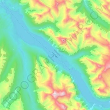
Name: Topografische Karte Maligne Lake, Höhe, Relief.
Ort: Maligne Lake, Improvement District No. 12, Alberta, Canada (52.59363 -117.64318 52.72898 -117.40968)
Durchschnittliche Höhe: 2.125 m
Minimale Höhe: 1.670 m
Maximale Höhe: 3.242 m
Spenden
Andere topografische Karten
Klicken Sie auf eine Karte, um ihre Topografie, ihre Höhe und ihr Relief anzuzeigen.
Medicine Lake
Canada > Alberta > Improvement District No. 12
Wildlife is surprisingly abundant along this high altitude lake. Grizzly bear, black bear, mule deer, caribou, wolves, moose and mountain sheep are some of the larger mammals that frequent the lake area during the summer season. Bald eagles, and osprey also frequent the area and live off the fish populations.
Durchschnittliche Höhe: 1.681 m
Mount Columbia
Canada > Alberta > Improvement District No. 12 > Area A (Kicking Horse/Kinbasket Lake)
Durchschnittliche Höhe: 2.843 m
Spenden