
Vielen Dank für die Unterstützung dieser Website ❤️
Spenden
Spenden
Topografische Karte Lac Ste. Anne
Klicken Sie auf die Karte, um die Höhe anzuzeigen.
Vielen Dank für die Unterstützung dieser Website ❤️
Spenden
Spenden
Lac Ste. Anne
The lake has a total area of 54.5 km2, a maximum depth of 9 m, and an average depth of 4.8 m. Lac Ste. Anne lies at an elevation of 730 m, and has a drainage area of 619 km2. The eutrophic lake is formed along the Sturgeon River through which it drains into the North Saskatchewan River. Two islands are found at the western end of the lake, Farming Island and Horse Island, while the small Castle Island and tiny Rock Island lie at the eastern tip of the lake.
Vielen Dank für die Unterstützung dieser Website ❤️
Spenden
Spenden
Über diese Karte
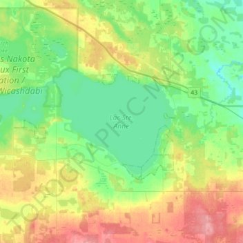
Name: Topografische Karte Lac Ste. Anne, Höhe, Relief.
Durchschnittliche Höhe: 740 m
Minimale Höhe: 710 m
Maximale Höhe: 795 m
Vielen Dank für die Unterstützung dieser Website ❤️
Spenden
Spenden