
Spenden
Topografische Karte Pembrokeshire
Klicken Sie auf die Karte, um die Höhe anzuzeigen.
Spenden
Pembrokeshire
There is little evidence of Roman occupation in what is now Pembrokeshire. Ptolemy's Geography, written c. 150, mentioned some coastal places, two of which have been identified as the River Teifi and what is now St Davids Head, but most Roman writers did not mention the area; there may have been a Roman settlement near St Davids and a road from Bath, but this comes from a 14th-century writer. Any evidence for villas or Roman building materials reported by mediaeval or later writers has not been verified, though some remains near Dale were tentatively identified as Roman in character by topographer Richard Fenton in his Historical Tour of 1810. Fenton stated that he had "...reason to be of opinion that they had not colonized Pembrokeshire till near the decline of their empire in Britain".
Spenden
Über diese Karte
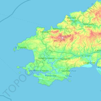
Name: Topografische Karte Pembrokeshire, Höhe, Relief.
Ort: Pembrokeshire, Wales, United Kingdom (51.59592 -5.67030 52.11804 -4.48559)
Durchschnittliche Höhe: 43 m
Minimale Höhe: 0 m
Maximale Höhe: 522 m
Spenden
Andere topografische Karten
Klicken Sie auf eine Karte, um ihre Topografie, ihre Höhe und ihr Relief anzuzeigen.
Cwm Idwal
United Kingdom > Wales > Gwynedd
Cwm Idwal is a cirque (or corrie) in the Glyderau range of mountains in northern Snowdonia, the national park in the mountainous region of North Wales. Its main interest is to hill walkers and rock climbers, but it is also of interest to geologists and naturalists, given its combination of altitude (relatively…
Durchschnittliche Höhe: 600 m
Spenden
Welshpool
United Kingdom > Wales > Powys
The Mermaid Inn, 28 High Street, was very probably an early 16th-century merchant's house, placed on a burgage plot between the High Street and Alfred Jones Court. The timber-framed building has long storehouse or wing to the rear. The frontage was remodelled c. 1890, by Frank H. Shayler, architect, of…
Durchschnittliche Höhe: 156 m
Spenden
Spenden
Spenden
Knighton
United Kingdom > Wales > Powys
The town became a borough in 1203, with a charter permitting a weekly market and annual fair. The presence of two castles within a comparatively small town suggests that one (the earlier motte and bailey sited atop the town) went out of use before the establishment of the second (the motte with no bailey at…
Durchschnittliche Höhe: 295 m
Spenden
Spenden
Spenden
Spenden
Spenden
South Stack Lighthouse
United Kingdom > Wales > Isle of Anglesey > Trearddur
Durchschnittliche Höhe: 17 m
Spenden
Spenden
Spenden
Spenden
Spenden
Spenden
Spenden
Spenden
Spenden
Spenden
Llanfairpwllgwyngyll
United Kingdom > Wales > Isle of Anglesey > Llanfairpwllgwyngyll
Durchschnittliche Höhe: 42 m
Spenden
Spenden
Spenden
Spenden
Spenden
Spenden