
Spenden
Topografische Karte Welshpool
Klicken Sie auf die Karte, um die Höhe anzuzeigen.
Spenden
Welshpool
The Mermaid Inn, 28 High Street, was very probably an early 16th-century merchant's house, placed on a burgage plot between the High Street and Alfred Jones Court. The timber-framed building has long storehouse or wing to the rear. The frontage was remodelled c. 1890, by Frank H. Shayler, architect, of Shrewsbury. Early illustrations of the building show that prior to this it had a thatched roof and that the timbering was not exposed. There is a passage to side with heavy box-framing in square panels, with brick infill exposed in side elevation and in rear wing. The frontage was exposed by Shayler to show decorative timber work on the upper storey. An Inn by the 19th century when it was owned by a family named Sparrow.
Spenden
Über diese Karte
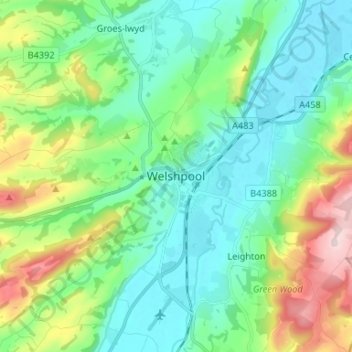
Name: Topografische Karte Welshpool, Höhe, Relief.
Ort: Welshpool, Powys, Wales, SY21 7SD, United Kingdom (52.62007 -3.18742 52.70007 -3.10742)
Durchschnittliche Höhe: 156 m
Minimale Höhe: 63 m
Maximale Höhe: 412 m
Spenden
Andere topografische Karten
Klicken Sie auf eine Karte, um ihre Topografie, ihre Höhe und ihr Relief anzuzeigen.
Brecon Beacons National Park
United Kingdom > Wales > Powys
Brecon Beacons National Park, officially named Bannau Brycheiniog National Park (Welsh pronunciation), is a national park in Wales. It is named after the Brecon Beacons (Welsh: Bannau Brycheiniog), the mountain range at its centre. The national park includes the highest mountain in South Wales, Pen y Fan,…
Durchschnittliche Höhe: 270 m
Spenden