
Spenden
Topografische Karte Cwm Idwal
Klicken Sie auf die Karte, um die Höhe anzuzeigen.
Spenden
Cwm Idwal
Cwm Idwal is a cirque (or corrie) in the Glyderau range of mountains in northern Snowdonia, the national park in the mountainous region of North Wales. Its main interest is to hill walkers and rock climbers, but it is also of interest to geologists and naturalists, given its combination of altitude (relatively high in UK terms), aspect (north-facing) and terrain (mountainous and rocky). In a 2005 poll conducted by Radio Times, Cwm Idwal was ranked the 7th greatest natural wonder in Britain.
Spenden
Über diese Karte
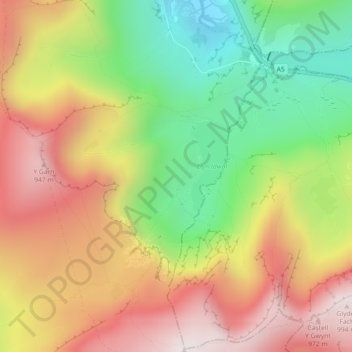
Name: Topografische Karte Cwm Idwal, Höhe, Relief.
Ort: Cwm Idwal, Llandygai, Gwynedd, Wales, LL57 3LZ, United Kingdom (53.10476 -4.04013 53.12476 -4.02013)
Durchschnittliche Höhe: 600 m
Minimale Höhe: 205 m
Maximale Höhe: 989 m
Spenden
Andere topografische Karten
Klicken Sie auf eine Karte, um ihre Topografie, ihre Höhe und ihr Relief anzuzeigen.