
Topografische Karte Vysoké Tatry
Interaktive Karte
Klicken Sie auf die Karte, um die Höhe anzuzeigen.
Über diese Karte
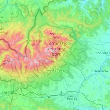
Name: Topografische Karte Vysoké Tatry, Höhe, Relief.
Ort: Vysoké Tatry, District of Poprad, Region of Prešov, Slovakia (49.08034 19.88393 49.28609 20.38501)
Durchschnittliche Höhe: 1.024 m
Minimale Höhe: 568 m
Maximale Höhe: 2.593 m
The town of Vysoké Tatry is special in many aspects. It is not a true town, but a conglomerate of separate and different settlements (originally separate villages), whose only common feature is that they are the main tourist resorts in the Slovak High Tatras, while being connected through a common railway network (the Tatra Railway). After the country's capital, the town is Slovakia's major tourist destination. It has around 4,000 inhabitants, excluding tourists. It is located at an elevation of 1,010 m (3,310 ft) above sea level. Covering 360.22 square kilometres (139.1 square miles), it is Slovakia's second-largest urban area, after the country's capital, and was the largest until 2007, when the village of Štrbské Pleso became a part of Štrba after Štrba's municipal government's successful claim on the Supreme Court.
Andere topografische Karten
Klicken Sie auf eine Karte, um ihre Topografie, ihre Höhe und ihr Relief anzuzeigen.
Bachledova dolina
Slovakia > Region of Prešov > District of Poprad > Ždiar
Bachledova dolina, Ždiar, District of Poprad, Region of Prešov, 059 55, Slovakia
Durchschnittliche Höhe: 996 m
Rysy
Slovakia > Region of Prešov > District of Poprad > Vysoké Tatry
Rysy, Vysoké Tatry, District of Poprad, Region of Prešov, Slovakia
Durchschnittliche Höhe: 2.005 m
Havran
Slovakia > Region of Prešov > District of Poprad > Tatranská Javorina
Havran, Tatranská Javorina, District of Poprad, Region of Prešov, Eastern Slovakia, 059 56, Slovakia
Durchschnittliche Höhe: 1.624 m
Nová Lesná
Slovakia > Region of Prešov > District of Poprad
Nová Lesná, District of Poprad, Region of Prešov, Eastern Slovakia, 059 86, Slovakia
Durchschnittliche Höhe: 790 m
Druhý Mních / Zadni Mnich
Slovakia > Region of Prešov > District of Poprad > Vysoké Tatry
Druhý Mních / Zadni Mnich, Vysoké Tatry, District of Poprad, Region of Prešov, Eastern Slovakia, Slovakia
Durchschnittliche Höhe: 1.921 m
Štrba
Slovakia > Region of Prešov > District of Poprad
Štrba, District of Poprad, Region of Prešov, Eastern Slovakia, Slovakia
Durchschnittliche Höhe: 1.134 m
Svit
Slovakia > Region of Prešov > District of Poprad
Svit, District of Poprad, Region of Prešov, Eastern Slovakia, 059 21, Slovakia
Durchschnittliche Höhe: 771 m
Poprad
Slovakia > Region of Prešov > District of Poprad > Poprad > Poprad
Poprad, District of Poprad, Region of Prešov, Eastern Slovakia, 05851, Slovakia
Durchschnittliche Höhe: 699 m
Tatra Mountains
Slovakia > Region of Prešov > District of Poprad
Tatra Mountains, District of Poprad, Region of Prešov, Central Slovakia, Slovakia
Durchschnittliche Höhe: 922 m
Poprad
Slovakia > Region of Prešov > District of Poprad
Poprad, District of Poprad, Region of Prešov, Eastern Slovakia, Slovakia
Durchschnittliche Höhe: 709 m
Vysoké Tatry
Slovakia > Region of Prešov > District of Poprad > Vysoké Tatry > Vysoké Tatry
Vysoké Tatry, District of Poprad, Region of Prešov, Eastern Slovakia, 062 01, Slovakia
Durchschnittliche Höhe: 1.107 m
Gerlachovský štít
Slovakia > Region of Prešov > District of Poprad > Vysoké Tatry
Gerlachovský štít, Vysoké Tatry, District of Poprad, Region of Prešov, Eastern Slovakia, 05984, Slovakia
Durchschnittliche Höhe: 2.103 m