
Topografische Karte Meeraugspitze
Interaktive Karte
Klicken Sie auf die Karte, um die Höhe anzuzeigen.
Meeraugspitze
Der Rysy (deutsch Meeraugspitze) ist ein Berg an der polnisch-slowakischen Grenze in der Hohen Tatra. Er besitzt zwei Gipfel. Der höchste Punkt liegt in der Slowakei und erreicht eine Höhe von 2501 m n.m. Der Nordwestgipfel ist mit 2500 m n.p.m. der höchste Berg Polens.
Über diese Karte
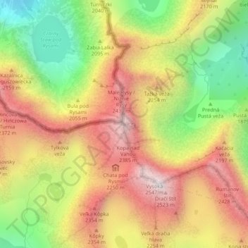
Name: Topografische Karte Meeraugspitze, Höhe, Relief.
Durchschnittliche Höhe: 2.005 m
Minimale Höhe: 1.423 m
Maximale Höhe: 2.528 m