
Topografische Karte Gerlachovský štít
Interaktive Karte
Klicken Sie auf die Karte, um die Höhe anzuzeigen.
Über diese Karte
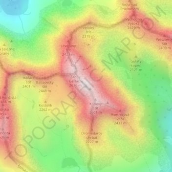
Name: Topografische Karte Gerlachovský štít, Höhe, Relief.
Durchschnittliche Höhe: 2.103 m
Minimale Höhe: 1.571 m
Maximale Höhe: 2.618 m
Usually listed at 2655 metres AMSL (8,711 ft), its exact elevation is actually 0.6 metres (2.0 feet) lower. The pyramidal shape of the massif is marked by a huge cirque. Despite its relatively low elevation, the about 2,000 m vertical rise from the valley floor makes Gerlachovský štít soar. Mistaken for an average mountain in the rugged High Tatras range in the more distant past, it has since played a symbolic role in the eyes of the rulers and populations of several Central European nations, to the point that between the 19th and mid-20th century, it had four different names with six name reversals. It managed to be the highest mountain of the Kingdom of Hungary, and of the countries of Czechoslovakia, Slovakia and then Czechoslovakia again within the span of less than three decades of the 20th century.
Andere topografische Karten
Klicken Sie auf eine Karte, um ihre Topografie, ihre Höhe und ihr Relief anzuzeigen.
Vysoké Tatry
Slovakia > Region of Prešov > District of Poprad > Vysoké Tatry > Vysoké Tatry
Vysoké Tatry, District of Poprad, Region of Prešov, Eastern Slovakia, 062 01, Slovakia
Durchschnittliche Höhe: 1.107 m