
Topografische Karte Iron Bridge
Klicken Sie auf die Karte, um die Höhe anzuzeigen.
Über diese Karte
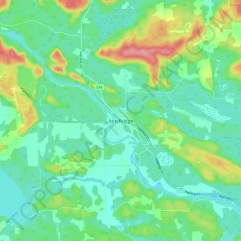
Name: Topografische Karte Iron Bridge, Höhe, Relief.
Durchschnittliche Höhe: 200 m
Minimale Höhe: 172 m
Maximale Höhe: 270 m
Andere topografische Karten
Klicken Sie auf eine Karte, um ihre Topografie, ihre Höhe und ihr Relief anzuzeigen.
Goulais River
Canada > Ontario > Algoma District > Unorganized North Algoma
Durchschnittliche Höhe: 362 m
Montreal River
Canada > Ontario > Algoma District > Unorganized North Algoma
Durchschnittliche Höhe: 360 m
Lucille Lake;Wood Creek
Canada > Ontario > Algoma District > Unorganized North Algoma
Durchschnittliche Höhe: 441 m
Alpha Lake
Canada > Ontario > Algoma District > Unorganized North Algoma
Durchschnittliche Höhe: 314 m
Daisy Lake
Canada > Ontario > Algoma District > Unorganized North Algoma
Durchschnittliche Höhe: 457 m
Raven Lake
Canada > Ontario > Algoma District > Unorganized North Algoma
Durchschnittliche Höhe: 371 m
Burnt Lake
Canada > Ontario > Algoma District > Unorganized North Algoma
Durchschnittliche Höhe: 444 m
St. Joseph Island
Canada > Ontario > Algoma District > Jocelyn Township
Its highest point, known colloquially and by surveyors as "the Mountain", is near the centre of the island near Carterton with an elevation of 345.6 m, which is about 169 m above Lake Huron.
Durchschnittliche Höhe: 196 m
Moccasin Lake
Canada > Ontario > Algoma District > Unorganized North Algoma
Durchschnittliche Höhe: 477 m
Clayton Lake
Canada > Ontario > Algoma District > Unorganized North Algoma
Durchschnittliche Höhe: 381 m
Kabinakagami Lake
Canada > Ontario > Algoma District > Unorganized North Algoma
Durchschnittliche Höhe: 332 m
Seymour Lake
Canada > Ontario > Algoma District > Unorganized North Algoma
Durchschnittliche Höhe: 436 m
Caddy Lake
Canada > Ontario > Algoma District > Unorganized North Algoma
Durchschnittliche Höhe: 424 m
Kirkpatrick Lake
Canada > Ontario > Algoma District > Unorganized North Algoma
Durchschnittliche Höhe: 429 m
Northland Lake
Canada > Ontario > Algoma District > Unorganized North Algoma
Durchschnittliche Höhe: 387 m
Manitowik Lake
Canada > Ontario > Algoma District > Unorganized North Algoma
Durchschnittliche Höhe: 394 m
Mosambik Lake
Canada > Ontario > Algoma District > Unorganized North Algoma
Durchschnittliche Höhe: 363 m
Fire River
Canada > Ontario > Algoma District > Unorganized North Algoma
Durchschnittliche Höhe: 399 m
Kimiwan Creek;Kimiwan Lakes
Canada > Ontario > Algoma District > Unorganized North Algoma
Durchschnittliche Höhe: 442 m
Tilley Lakes
Canada > Ontario > Algoma District > Unorganized North Algoma
Durchschnittliche Höhe: 301 m
Limerick Lake
Canada > Ontario > Algoma District > Unorganized North Algoma
Durchschnittliche Höhe: 505 m
Lauzon Lake
Canada > Ontario > Algoma District > The North Shore Township > Algoma Mills
Durchschnittliche Höhe: 210 m
Rose Lake
Canada > Ontario > Algoma District > Plummer Additional Township
Durchschnittliche Höhe: 235 m
Mashagama Lake
Canada > Ontario > Algoma District > Unorganized North Algoma
Durchschnittliche Höhe: 458 m
Montreal Island
Canada > Ontario > Algoma District > Unorganized North Algoma
Durchschnittliche Höhe: 190 m
East Davignon Creek
Canada > Ontario > Algoma District > Sault Ste. Marie
Durchschnittliche Höhe: 202 m
Lanier Lake
Canada > Ontario > Algoma District > Unorganized North Algoma
Durchschnittliche Höhe: 403 m
Kabinakagamisis Lake
Canada > Ontario > Algoma District > Unorganized North Algoma
Durchschnittliche Höhe: 324 m
Chapleau River
Canada > Ontario > Algoma District > Unorganized North Algoma
Durchschnittliche Höhe: 328 m
Esnagi Lake
Canada > Ontario > Algoma District > Unorganized North Algoma
Durchschnittliche Höhe: 391 m
Wakomata Lake
Canada > Ontario > Algoma District > Unorganized North Algoma
Durchschnittliche Höhe: 380 m
St. Joseph Island
Canada > Ontario > Algoma District > Jocelyn Township
Its highest point, known colloquially and by surveyors as "the Mountain", is near the centre of the island near Carterton with an elevation of 345.6 m, which is about 169 m above Lake Huron.
Durchschnittliche Höhe: 196 m
Flack Lake
Canada > Ontario > Algoma District > Unorganized North Algoma
Durchschnittliche Höhe: 384 m