
Vielen Dank für die Unterstützung dieser Website ❤️
Spenden
Spenden
Topografische Karte Sault Ste. Marie
Klicken Sie auf die Karte, um die Höhe anzuzeigen.
Vielen Dank für die Unterstützung dieser Website ❤️
Spenden
Spenden
Über diese Karte
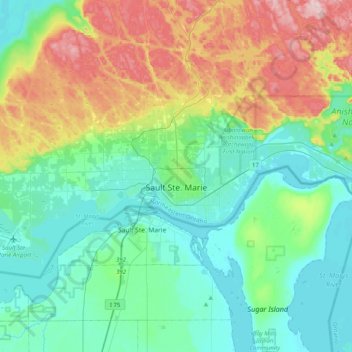
Name: Topografische Karte Sault Ste. Marie, Höhe, Relief.
Durchschnittliche Höhe: 249 m
Minimale Höhe: 173 m
Maximale Höhe: 452 m
Vielen Dank für die Unterstützung dieser Website ❤️
Spenden
Spenden
Andere topografische Karten
Klicken Sie auf eine Karte, um ihre Topografie, ihre Höhe und ihr Relief anzuzeigen.
Cedar Island
Canada > Ontario > Algoma District > Plummer Additional Township
Durchschnittliche Höhe: 216 m
Searchmont
Canada > Ontario > Algoma District > Unorganized North Algoma
Durchschnittliche Höhe: 285 m
Pancake Bay
Canada > Ontario > Algoma District > Unorganized North Algoma
Durchschnittliche Höhe: 180 m
Vielen Dank für die Unterstützung dieser Website ❤️
Spenden
Spenden
Obakamiga River;Redfin Lake
Canada > Ontario > Algoma District > Unorganized North Algoma
Durchschnittliche Höhe: 343 m
Vielen Dank für die Unterstützung dieser Website ❤️
Spenden
Spenden
Goulais Bay
Canada > Ontario > Algoma District > Unorganized North Algoma
Durchschnittliche Höhe: 189 m