
Vielen Dank für die Unterstützung dieser Website ❤️
Spenden
Spenden
Topografische Karte St. Joseph Island
Klicken Sie auf die Karte, um die Höhe anzuzeigen.
Vielen Dank für die Unterstützung dieser Website ❤️
Spenden
Spenden
St. Joseph Island
Its highest point, known colloquially and by surveyors as "the Mountain", is near the centre of the island near Carterton with an elevation of 345.6 m, which is about 169 m above Lake Huron.
Vielen Dank für die Unterstützung dieser Website ❤️
Spenden
Spenden
Über diese Karte
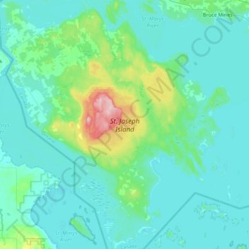
Name: Topografische Karte St. Joseph Island, Höhe, Relief.
Durchschnittliche Höhe: 196 m
Minimale Höhe: 171 m
Maximale Höhe: 348 m
Vielen Dank für die Unterstützung dieser Website ❤️
Spenden
Spenden