
Spenden
Topografische Karte Whitewater Region
Klicken Sie auf die Karte, um die Höhe anzuzeigen.
Spenden
Über diese Karte
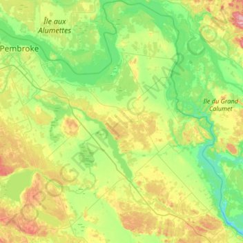
Name: Topografische Karte Whitewater Region, Höhe, Relief.
Durchschnittliche Höhe: 141 m
Minimale Höhe: 74 m
Maximale Höhe: 298 m
Spenden
Andere topografische Karten
Klicken Sie auf eine Karte, um ihre Topografie, ihre Höhe und ihr Relief anzuzeigen.
Golden Lake
Canada > Ontario > Renfrew County > North Algona Wilberforce
Durchschnittliche Höhe: 185 m
Foymount
Canada > Ontario > Renfrew County > Bonnechere Valley
The location is also popular for amateur astronomers given the high altitude and low levels of artificial light.
Durchschnittliche Höhe: 432 m
Spenden
Spenden
Palmer Rapids
Canada > Ontario > Renfrew County > Brudenell, Lyndoch and Raglan
Durchschnittliche Höhe: 319 m
Quadeville
Canada > Ontario > Renfrew County > Brudenell, Lyndoch and Raglan
Durchschnittliche Höhe: 333 m
Bonnechere
Canada > Ontario > Renfrew County > Killaloe, Hagarty and Richards
Durchschnittliche Höhe: 174 m
Spenden
Killaloe
Canada > Ontario > Renfrew County > Killaloe, Hagarty and Richards
Durchschnittliche Höhe: 182 m
Spenden
Madawaska River
Canada > Ontario > Renfrew County > Greater Madawaska > Calabogie
Durchschnittliche Höhe: 160 m
Eagles Nest Lookout
Canada > Ontario > Renfrew County > Greater Madawaska
Durchschnittliche Höhe: 246 m
Spenden
Lorwall Lake
Canada > Ontario > Renfrew County > Brudenell, Lyndoch and Raglan
Durchschnittliche Höhe: 401 m
Spenden
Spenden
Spenden
Spenden
Spenden
Spenden
Mount St. Patrick Mountains
Canada > Ontario > Renfrew County > Greater Madawaska
Durchschnittliche Höhe: 390 m
Madawaska Highlands
Canada > Ontario > Renfrew County > Killaloe, Hagarty and Richards
Durchschnittliche Höhe: 272 m
Spenden
Killaloe
Canada > Ontario > Renfrew County > Killaloe, Hagarty and Richards
Durchschnittliche Höhe: 182 m
Killaloe
Canada > Ontario > Renfrew County > Killaloe, Hagarty and Richards
Durchschnittliche Höhe: 182 m
Spenden
Spenden