
Spenden
Topografische Karte Mount Calliope
Klicken Sie auf die Karte, um die Höhe anzuzeigen.
Spenden
Über diese Karte
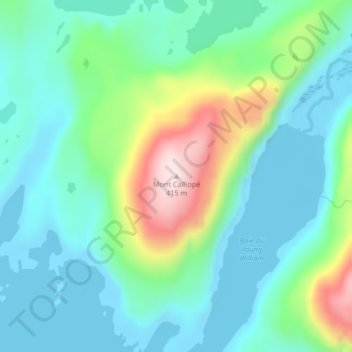
Name: Topografische Karte Mount Calliope, Höhe, Relief.
Durchschnittliche Höhe: 102 m
Minimale Höhe: -3 m
Maximale Höhe: 400 m
Spenden
Andere topografische Karten
Klicken Sie auf eine Karte, um ihre Topografie, ihre Höhe und ihr Relief anzuzeigen.
Kerguelen Archipelago
France > French Southern and Antarctic Lands
The highest point is Mont Ross in the Gallieni Massif, which rises along the southern coast of the island and has an elevation of 1,850 metres (6,070 ft). The Cook Ice Cap (French: Calotte Glaciaire Cook), France's largest glacier with an area of about 403 km2 (156 sq mi), lies on the west-central part of the…
Durchschnittliche Höhe: 38 m
Kerguelen Island
France > French Southern and Antarctic Lands
The highest point is Mont Ross in the Gallieni Massif, which rises along the southern coast of the island and has an elevation of 1,850 metres (6,070 ft). The Cook Ice Cap (French: Calotte Glaciaire Cook), France's largest glacier with an area of about 403 km2 (156 sq mi), lies on the west-central part of the…
Durchschnittliche Höhe: 45 m
Kerguelen Archipelago
France > French Southern and Antarctic Lands
The highest point is Mont Ross in the Gallieni Massif, which rises along the southern coast of the island and has an elevation of 1,850 metres (6,070 ft). The Cook Ice Cap (French: Calotte Glaciaire Cook), France's largest glacier with an area of about 403 km2 (156 sq mi), lies on the west-central part of the…
Durchschnittliche Höhe: 38 m
Spenden
Kerguelen Archipelago
France > French Southern and Antarctic Lands
The highest point is Mont Ross in the Gallieni Massif, which rises along the southern coast of the island and has an elevation of 1,850 metres (6,070 ft). The Cook Ice Cap (French: Calotte Glaciaire Cook), France's largest glacier with an area of about 403 km2 (156 sq mi), lies on the west-central part of the…
Durchschnittliche Höhe: 38 m
Spenden
Kerguelen Archipelago
France > French Southern and Antarctic Lands
The highest point is Mont Ross in the Gallieni Massif, which rises along the southern coast of the island and has an elevation of 1,850 metres (6,070 ft). The Cook Ice Cap (French: Calotte Glaciaire Cook), France's largest glacier with an area of about 403 km2 (156 sq mi), lies on the west-central part of the…
Durchschnittliche Höhe: 38 m
Possession Island
France > French Southern and Antarctic Lands
The island has been identified as an Important Bird Area (IBA) by BirdLife International as a breeding site for seabirds, of which there are at least 26 breeding species. Birds nesting in relatively large numbers include king, northern rockhopper and macaroni penguins, wandering, sooty and light-mantled…
Durchschnittliche Höhe: 13 m
Spenden
Possession Island
France > French Southern and Antarctic Lands
The island has been identified as an Important Bird Area (IBA) by BirdLife International as a breeding site for seabirds, of which there are at least 26 breeding species. Birds nesting in relatively large numbers include king, northern rockhopper and macaroni penguins, wandering, sooty and light-mantled…
Durchschnittliche Höhe: 13 m