
Spenden
Topografische Karte Kerguelen Archipelago
Klicken Sie auf die Karte, um die Höhe anzuzeigen.
Spenden
Kerguelen Archipelago
The highest point is Mont Ross in the Gallieni Massif, which rises along the southern coast of the island and has an elevation of 1,850 metres (6,070 ft). The Cook Ice Cap (French: Calotte Glaciaire Cook), France's largest glacier with an area of about 403 km2 (156 sq mi), lies on the west-central part of the island. Overall, the glaciers of the Kerguelen Islands cover just over 500 km2 (190 sq mi). Grande Terre has also numerous bays, inlets, fjords, and coves, as well as several peninsulas and promontories. The most important ones are listed below.
Spenden
Über diese Karte
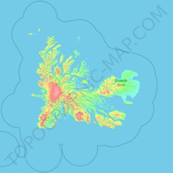
Name: Topografische Karte Kerguelen Archipelago, Höhe, Relief.
Durchschnittliche Höhe: 38 m
Minimale Höhe: -2 m
Maximale Höhe: 1.451 m
Spenden
Andere topografische Karten
Klicken Sie auf eine Karte, um ihre Topografie, ihre Höhe und ihr Relief anzuzeigen.