
Spenden
Topografische Karte Possession Island
Klicken Sie auf die Karte, um die Höhe anzuzeigen.
Spenden
Possession Island
The island has been identified as an Important Bird Area (IBA) by BirdLife International as a breeding site for seabirds, of which there are at least 26 breeding species. Birds nesting in relatively large numbers include king, northern rockhopper and macaroni penguins, wandering, sooty and light-mantled albatrosses, northern giant petrels, medium-billed prions, Kerguelen and soft-plumaged petrels, and South Georgia diving petrels. Other island breeders in smaller numbers are southern giant petrels, grey-headed albatrosses and Kerguelen terns. Crozet blue-eyed shags, black-faced sheathbills and Eaton's pintails are resident. The smaller birds nest only at higher altitudes because of their vulnerability to rat predation at lower levels.
Spenden
Über diese Karte
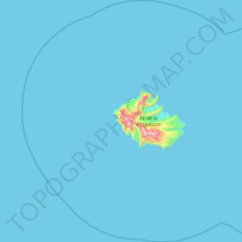
Name: Topografische Karte Possession Island, Höhe, Relief.
Durchschnittliche Höhe: 13 m
Minimale Höhe: 0 m
Maximale Höhe: 897 m
Spenden
Andere topografische Karten
Klicken Sie auf eine Karte, um ihre Topografie, ihre Höhe und ihr Relief anzuzeigen.