
Topografische Karte Ketkawale
Interaktive Karte
Klicken Sie auf die Karte, um die Höhe anzuzeigen.
Über diese Karte
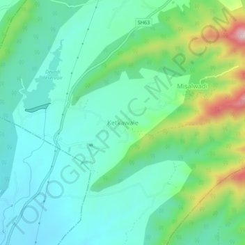
Name: Topografische Karte Ketkawale, Höhe, Relief.
Ort: Ketkawale, Purandhar, Pune, Maharashtra, 412302, India (18.24034 73.91799 18.28034 73.95799)
Durchschnittliche Höhe: 754 m
Minimale Höhe: 647 m
Maximale Höhe: 1.071 m
Andere topografische Karten
Klicken Sie auf eine Karte, um ihre Topografie, ihre Höhe und ihr Relief anzuzeigen.
Malhargad Fort
India > Maharashtra > Purandhar
Malhargad Fort, Malhargad Walking Path, Purandhar, Pune District, Maharashtra, India
Durchschnittliche Höhe: 822 m
Garade
India > Maharashtra > Purandhar
Garade, Purandhar, Pune, Maharashtra, 412205, India
Durchschnittliche Höhe: 883 m
Saswad
India > Maharashtra > Purandhar
Saswad, Purandhar, Pune, Maharashtra, 412300, India
Durchschnittliche Höhe: 787 m
Narayanpur
India > Maharashtra > Purandhar
Narayanpur, Purandhar, Maharashtra, 412302, India
Durchschnittliche Höhe: 924 m
Jejuri
India > Maharashtra > Purandhar
Jejuri, Purandhar, Pune, Maharashtra, 412303, India
Durchschnittliche Höhe: 728 m
Kalewadi
India > Maharashtra > Purandhar
Kalewadi, Purandhar, Pune, Maharashtra, India
Durchschnittliche Höhe: 839 m