
Vielen Dank für die Unterstützung dieser Website ❤️
Spenden
Spenden
Topografische Karte Narayanpur
Klicken Sie auf die Karte, um die Höhe anzuzeigen.
Vielen Dank für die Unterstützung dieser Website ❤️
Spenden
Spenden
Über diese Karte
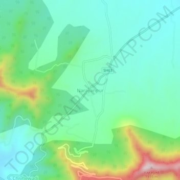
Name: Topografische Karte Narayanpur, Höhe, Relief.
Ort: Narayanpur, Purandhar, Maharashtra, 412302, India (18.28154 73.95482 18.32154 73.99482)
Durchschnittliche Höhe: 924 m
Minimale Höhe: 781 m
Maximale Höhe: 1.327 m
Vielen Dank für die Unterstützung dieser Website ❤️
Spenden
Spenden
Andere topografische Karten
Klicken Sie auf eine Karte, um ihre Topografie, ihre Höhe und ihr Relief anzuzeigen.