
Topografische Karte Andhra Pradesh
Klicken Sie auf die Karte, um die Höhe anzuzeigen.
Andhra Pradesh
Andhra Pradesh topographical map
Über diese Karte
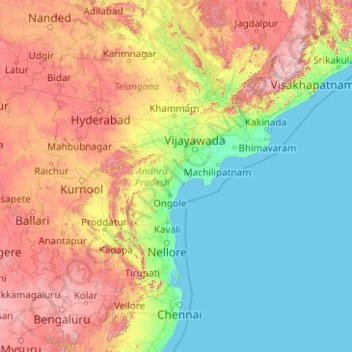
Name: Topografische Karte Andhra Pradesh, Höhe, Relief.
Ort: Andhra Pradesh, India (12.62386 76.76008 19.16681 84.76580)
Durchschnittliche Höhe: 269 m
Minimale Höhe: -1 m
Maximale Höhe: 1.585 m
Andere topografische Karten
Klicken Sie auf eine Karte, um ihre Topografie, ihre Höhe und ihr Relief anzuzeigen.
Surat
India > Gujarat > Katargam Taluka > Surat
Surat is a port city situated on the banks of the Tapi river. Damming of the Tapi caused the original port facilities to close; the nearest port is now in the Magadalla and Hazira area of Surat Metropolitan Region.It has famous beach called 'Dumas Beach' located in Hazira. The city is located at 21°10′N…
Durchschnittliche Höhe: 11 m
Guwahati
Professor Abani Kumar Bhagawati of Gauhati University stated that since before there were sufficient wetlands to absorb rainwater and channels to carry excess water to the Brahmaputra, the city did not experience floods. However, human interference has disrupted the natural topography, leading to the current…
Durchschnittliche Höhe: 113 m
Patna
India > Bihar > Patna Rural
Patna is on the southern bank of the river Ganges. The total area of Patna is 250 km2 (97 sq mi). Of this, the municipal area constitutes 109.218 km2 (42.169 sq mi). The suburban area covers 140.782 km2 (54.356 sq mi). It has an average elevation of 53 m (174 ft). A characteristic feature of the geography of…
Durchschnittliche Höhe: 51 m
Dhanbad
India > Jharkhand > Dhanbad-Cum-Kenduadih-Cum-Jagata
Dhanbad has an average elevation of 227 m (745 ft). Its geographical length (extending from north to south) is 15 miles (24 km) and the breadth (stretching across east to West) is 10 miles (16 km). It shares its boundaries with West Bengal in the eastern and southern part, Dumka and Giridih in the North and…
Durchschnittliche Höhe: 212 m
Kolhapur
India > Maharashtra > Karvir
Kolhapur is an inland city located in south-west Maharashtra state, 373 km (232 mi) south of Mumbai and 228 km (142 mi) south of Pune, 615 km (382 mi) north-west of Bengaluru and 530 km (330 mi) west of Hyderabad. Within Maharashtra, Kolhapur's nearest cities and towns are Ichalkaranji 27 km (17 mi), Kodoli 35…
Durchschnittliche Höhe: 592 m
Ayodhya
India > Uttar Pradesh > Faizabad
The earliest of the Buddhist Pali-language texts and the Jain Prakrit-language texts mention a city called Saketa (Sageya or Saeya in Prakrit) as an important city of the Kosala mahajanapada. Topographical indications in both Buddhist and Jain texts suggest that Saketa is the same as the present-day Ayodhya.…
Durchschnittliche Höhe: 96 m
Vadodara
India > Gujarat > Vadodara Rural Taluka
Vadodara is located at 22°18′N 73°11′E / 22.30°N 73.19°E / 22.30; 73.19 in western India at an elevation of 39 metres (128 ft). It is the tenth-largest city in India with an area of 400 square kilometres (150 sq mi) and a population of 3.5 million, according to the 2010–11 census. The city…
Durchschnittliche Höhe: 36 m
Mount Abu
India > Rajasthan > Abu Road Tehsil
Mount Abu town, the only hill station in Rajasthan, is at an elevation of 1,220 m (4,003 ft). It has been a popular retreat from the heat of Rajasthan and neighboring Gujarat for centuries.
Durchschnittliche Höhe: 914 m
Kunigal
India > Karnataka > Kunigal taluk
Kunigal is located at 13°01′N 77°02′E / 13.02°N 77.03°E / 13.02; 77.03. It has an average elevation of 773 metres (2536 feet). It is situated on the National Highway 75 (India) connecting Bengaluru and Mangaluru and State Highway 33 (Karnataka) connecting Tumakuru and Madduru. Kunigal is…
Durchschnittliche Höhe: 775 m
Vellore
India > Tamil Nadu > Vellore
Vellore is at 12°55′N 79°08′E / 12.92°N 79.13°E / 12.92; 79.13, 220m above sea level. The city has a tropical savanna climate. It is in the Vellore district of the South Indian state, Tamil Nadu, 135 km (84 mi) west of the state capital Chennai and 30 km (19 mi) kms South of its twin city…
Durchschnittliche Höhe: 283 m
Salem
Salem is located at 11°40′N 78°08′E / 11.67°N 78.14°E / 11.67; 78.14, at an average elevation of 278 m (912 ft). The city is surrounded by hills: Nagaramalai on the north, Jarugumalai on the south, Kanjamalai on the west, Godumalai on the east and the Shevaroy Hills on the northeast.…
Durchschnittliche Höhe: 418 m
Maharashtra
Maharashtra is the third largest state by area in India. The Western Ghats better known as Sahyadri, are a hilly range running parallel to the coast, at an average elevation of 1,200 metres (4,000 ft). Kalsubai, a peak in the Sahyadris, near Nashik city is the highest elevated point in Maharashtra. To the west…
Durchschnittliche Höhe: 478 m
Thrissur
Thrissur is the headquarters of Thrissur district, in the centre of the Indian state of Kerala. The city is 75 km north-east of Kochi, 133 km south-west of Coimbatore, 124 km south-east of Kozhikode and 151 km north of Changanacherry. The city is located in a hillock called Thekkinkadu Maidan which is the…
Durchschnittliche Höhe: 36 m
Visakhapatnam
India > Andhra Pradesh > Visakhapatnam (Urban)
The city is situated between the Eastern Ghats and the Bay of Bengal. The city coordinates lies between 17.7041 N and 83.2977 E. The city's area is 682 km2. The average elevation is 45 metres. Visakhpatnam is situated in Coastal Andhra Region.
Durchschnittliche Höhe: 35 m
Bhopal
India > Madhya Pradesh > Huzur Tahsil
Bhopal has an average elevation of 500 metres (1401 ft) and is located in the central part of India, just north of the upper limit of the Vindhya mountain ranges. Located on the Malwa plateau, it is higher than the north Indian plains and the land rises towards the Vindhya Range to the south. The city has…
Durchschnittliche Höhe: 498 m
Ranchi
Ranchi lies at 23°22′N 85°20′E / 23.36°N 85.33°E / 23.36; 85.33 near to the Tropic of Cancer. The city covers an area of 175 km2 (68 sq mi) and its average elevation is 651 m above sea level. Ranchi is located in the southern part of the Chota Nagpur plateau, which is the eastern section of…
Durchschnittliche Höhe: 648 m
Mumbai
Mumbai lies at the mouth of the Ulhas River on the western coast of India, in the coastal region known as the Konkan. It sits on Salsette Island (Sashti Island), which it partially shares with the Thane district. Mumbai is bounded by the Arabian Sea to the west. Many parts of the city lie just above sea level,…
Durchschnittliche Höhe: 13 m
Pimpri-Chinchwad
India > Maharashtra > Haveli
Pimpri-Chinchwad also known as "PCMC", is a city in the Indian state of Maharashtra. The city is about 15 km (9.3 mi) northwest of the historic city of Pune, at an altitude of 590 m (1,940 ft) above sea level. It is the fifth largest city in Maharashtra and the nineteenth largest city in India and the…
Durchschnittliche Höhe: 571 m
Western Ghats
The range starts near south of the Tapti river and runs approximately 1,600 km (990 mi) through the states of Gujarat, Maharashtra, Karnataka, Goa, Kerala and Tamil Nadu ending at Marunthuvazh Malai, Swamithope near the southern tip of India. These hills cover 160,000 km2 (62,000 sq mi) and form the catchment…
Durchschnittliche Höhe: 2.225 m
Udaipur
India > Rajasthan > Girwa Tehsil
Udaipur is located at 24°31′30″N 73°40′38″E / 24.525049°N 73.677116°E / 24.525049; 73.677116. The city covers an area of 64 km2 (25 sq mi) and lies at an altitude of 598.00 m (1,962 ft) above sea level. It is located in the southern region of Rajasthan, near the Gujarat border. The city…
Durchschnittliche Höhe: 656 m
Dehradun
India > Uttarakhand > Dehradun
The city of Dehradun mainly lies in Doon Valley and is at a varying height from 410 m (1,350 ft) in Clement Town to above 700 m (2,300 ft) at Malsi which is 15 km (9.3 mi) from the city. However, the average elevation is 450 m (1,480 ft) above sea level. Malsi is the starting point of Lesser Himalayan Range…
Durchschnittliche Höhe: 904 m
Kufri
India > Himachal Pradesh > Shimla ( Rural )
Kufri is located at 31°06′N 77°15′E / 31.10°N 77.25°E / 31.10; 77.25. It has an average elevation of 2,720 metres (8923 feet).
Durchschnittliche Höhe: 2.095 m
Hunsur
India > Karnataka > Hunasuru taluk
Hunsur is located at 12°19′N 76°17′E / 12.31°N 76.29°E / 12.31; 76.29. It is located at an elevation of 805 metres (2,641 ft) above mean sea level. The river Lakshmana Tirtha flows through the town and two bridges are built across the river. The town is the administrative center of Hunsur…
Durchschnittliche Höhe: 792 m
Amritsar
India > Punjab > Amritsar I Tahsil
Amritsar is located at 31°38′N 74°52′E / 31.63°N 74.87°E / 31.63; 74.87 with an average elevation of 234 metres (768 ft) in the Majha region of the state of Punjab in North India and lies about 15 miles (24 km) east of the border with Pakistan. Administrative towns includes Ajnala, Attari,…
Durchschnittliche Höhe: 231 m
Bengaluru
India > Karnataka > Bangalore North
Bengaluru lies in the southeast of the South Indian state of Karnataka in the heart of the Mysore Plateau (a region of the larger Deccan Plateau) at an average elevation of 900 m (2,953 ft). The city covers an area of 741 km2 (286 sq mi). The Bengaluru metropolitan region covers an area of 7,005 km2 (2,705 sq…
Durchschnittliche Höhe: 879 m
Arani
India > Tamil Nadu > Arani
Arni is located at 12°40′N 79°17′E / 12.67°N 79.28°E / 12.67; 79.28 on the banks of the Kamandala Naaga river. It has an average elevation of 151 metres (495 ft).
Durchschnittliche Höhe: 143 m
Warangal
India > Telangana > Warangal mandal
Warangal is located at 18°00′N 79°35′E / 18.0°N 79.58°E / 18.0; 79.58. It has an average elevation of 302 metres (990 feet). It is settled in the eastern part of Deccan Plateau made up of granite rocks and hill formations which left the region barren making the cultivation dependent on…
Durchschnittliche Höhe: 268 m
Payyanur
India > Kerala > Payyannur Taluk > Payyanur
Payyannur is located at coordinates 12°06′N 75°12′E / 12.1°N 75.2°E / 12.1; 75.2. It has an average elevation of 16 metres (51 feet).
Durchschnittliche Höhe: 8 m