
Topografische Karte Tennessee
Interaktive Karte
Klicken Sie auf die Karte, um die Höhe anzuzeigen.
Über diese Karte
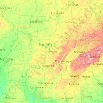
Name: Topografische Karte Tennessee, Höhe, Relief.
Ort: Tennessee, United States (34.98294 -90.31030 36.67812 -81.64722)
Durchschnittliche Höhe: 233 m
Minimale Höhe: 17 m
Maximale Höhe: 1.897 m
Tennessee has diverse terrain and landforms, and from east to west, contains a mix of cultural features characteristic of Appalachia, the Upland South, and the Deep South. The Blue Ridge Mountains along the eastern border reach some of the highest elevations in eastern North America, and the Cumberland Plateau contains many scenic valleys and waterfalls. The central part of the state is marked by cavernous bedrock and irregular rolling hills, and level, fertile plains define West Tennessee. The state is twice bisected by the Tennessee River, and the Mississippi River forms its western border. Its economy is dominated by the health care, music, finance, automotive, chemical, electronics, and tourism sectors, and cattle, soybeans, corn, poultry, and cotton are its primary agricultural products. The Great Smoky Mountains National Park, the nation's most visited national park, is in eastern Tennessee.
Andere topografische Karten
Klicken Sie auf eine Karte, um ihre Topografie, ihre Höhe und ihr Relief anzuzeigen.
Los Angeles
Los Angeles, California, United States
Durchschnittliche Höhe: 241 m
Brooklyn
United States > New York > New York
Brooklyn, Kings County, New York, United States
Durchschnittliche Höhe: 9 m
Houston
United States > Texas > Harris County
Houston, Harris County, Texas, United States
Durchschnittliche Höhe: 25 m
Santa Cruz
United States > California > Santa Cruz County
Santa Cruz, Santa Cruz County, California, United States
Durchschnittliche Höhe: 89 m
Aurora
United States > Colorado > Adams County
Aurora, Adams County, Colorado, United States
Durchschnittliche Höhe: 1.691 m
Albuquerque
United States > New Mexico > Bernalillo County
Albuquerque, Bernalillo County, New Mexico, United States
Durchschnittliche Höhe: 1.688 m
Santa Barbara
United States > California > Santa Barbara County
Santa Barbara, Santa Barbara County, California, United States
Durchschnittliche Höhe: 119 m
Hillsborough County
Hillsborough County, Florida, United States
Durchschnittliche Höhe: 20 m
Jacksonville
United States > Florida > Duval County
Jacksonville, Duval County, Florida, United States
Durchschnittliche Höhe: 10 m
Whatcom County
Whatcom County, Washington, United States
Durchschnittliche Höhe: 753 m
Indianapolis
United States > Indiana > Indianapolis
Indianapolis, Marion County, Indiana, 46204, United States
Durchschnittliche Höhe: 241 m
Manhattan
United States > New York > New York County > New York
Manhattan, New York County, New York, United States
Durchschnittliche Höhe: 16 m
Arlington
United States > Massachusetts > Middlesex County
Arlington, Middlesex County, Massachusetts, United States
Durchschnittliche Höhe: 35 m
Lexington
United States > Kentucky > Lexington
Lexington, Fayette County, Kentucky, 40508, United States
Durchschnittliche Höhe: 285 m
Allegheny County
Allegheny County, Pennsylvania, United States
Durchschnittliche Höhe: 325 m
Parker
United States > Colorado > Douglas County
Parker, Douglas County, Colorado, 80134, United States
Durchschnittliche Höhe: 1.845 m
Cape Cod
United States > Massachusetts > Plymouth County
Cape Cod, Plymouth County, Massachusetts, United States
Durchschnittliche Höhe: 2 m
Lakewood
United States > Colorado > Jefferson County > Lakewood
Lakewood, Jefferson County, Colorado, United States
Durchschnittliche Höhe: 1.717 m