
Topografische Karte South Dakota
Interaktive Karte
Klicken Sie auf die Karte, um die Höhe anzuzeigen.
Über diese Karte
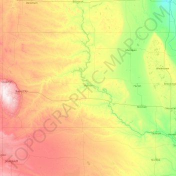
Name: Topografische Karte South Dakota, Höhe, Relief.
Ort: South Dakota, United States (42.47989 -104.05776 45.94545 -96.43634)
Durchschnittliche Höhe: 717 m
Minimale Höhe: 274 m
Maximale Höhe: 2.166 m
Black Elk Peak, formerly named Harney Peak, with an elevation of 7,242 ft (2,207 m), is the state's highest point, while the shoreline of Big Stone Lake is the lowest, with an elevation of 966 ft (294 m). South Dakota is bordered to the north by North Dakota; to the south by Nebraska; to the east by Iowa and Minnesota; and to the west by Wyoming and Montana. The geographical center of the U.S. is 17 miles (27 km) west of Castle Rock in Butte County. The North American continental pole of inaccessibility is between Allen and Kyle, 1,024 mi (1,648 km) from the nearest coastline.
Andere topografische Karten
Klicken Sie auf eine Karte, um ihre Topografie, ihre Höhe und ihr Relief anzuzeigen.
Montgomery County
Montgomery County, Texas, United States
Durchschnittliche Höhe: 69 m
Houston
United States > Texas > Harris County
Houston, Harris County, Texas, United States
Durchschnittliche Höhe: 25 m
The Woodlands
United States > Texas > Montgomery County
The Woodlands, Montgomery County, Texas, United States
Durchschnittliche Höhe: 47 m
Los Angeles
Los Angeles, Los Angeles County, California, United States
Durchschnittliche Höhe: 241 m
Brooklyn
United States > New York > New York
Brooklyn, Kings County, New York, United States
Durchschnittliche Höhe: 9 m
New Orleans
United States > Louisiana > Orleans Parish
New Orleans, Orleans Parish, Louisiana, United States
Durchschnittliche Höhe: 1 m
Boulder
United States > Colorado > Boulder County
Boulder, Boulder County, Colorado, United States
Durchschnittliche Höhe: 1.785 m
Jacksonville
United States > Florida > Duval County
Jacksonville, Duval County, Florida, United States
Durchschnittliche Höhe: 10 m
Albuquerque
United States > New Mexico > Bernalillo County
Albuquerque, Bernalillo County, New Mexico, United States
Durchschnittliche Höhe: 1.688 m
Middle East
United States > Maryland > Baltimore
Middle East, Baltimore, Maryland, United States
Durchschnittliche Höhe: 29 m
Appalachian Mountains
United States > North Carolina > Yancey County
Appalachian Mountains, Yancey County, North Carolina, United States
Durchschnittliche Höhe: 1.463 m
Miami-Dade County
Miami-Dade County, Florida, United States
Durchschnittliche Höhe: 3 m
College Station
United States > Texas > Brazos County
College Station, Brazos County, Texas, United States
Durchschnittliche Höhe: 87 m
Hillsborough County
Hillsborough County, Florida, United States
Durchschnittliche Höhe: 20 m
Great Smoky Mountains National Park
United States > Tennessee > Sevier County
Great Smoky Mountains National Park, Sevier County, East Tennessee, Tennessee, United States
Durchschnittliche Höhe: 765 m
Hudson River
Hudson River, New Jersey, 12834:12871, United States
Durchschnittliche Höhe: 297 m
Spokane
United States > Washington > Spokane County
Spokane, Spokane County, Washington, United States
Durchschnittliche Höhe: 655 m