
Topografische Karte Montana
Interaktive Karte
Klicken Sie auf die Karte, um die Höhe anzuzeigen.
Über diese Karte
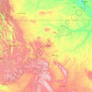
Name: Topografische Karte Montana, Höhe, Relief.
Ort: Montana, United States (44.35792 -116.04923 49.00111 -104.03956)
Durchschnittliche Höhe: 1.357 m
Minimale Höhe: 552 m
Maximale Höhe: 4.034 m
The state's topography is roughly defined by the Continental Divide, which splits much of the state into distinct eastern and western regions. Most of Montana's hundred or more named mountain ranges are in the state's western half, most of which is geologically and geographically part of the northern Rocky Mountains. The Absaroka and Beartooth ranges in the state's south-central part are technically part of the Central Rocky Mountains. The Rocky Mountain Front is a significant feature in the state's north-central portion, and isolated island ranges that interrupt the prairie landscape common in the central and eastern parts of the state. About 60 percent of the state is prairie, part of the northern Great Plains.
Andere topografische Karten
Klicken Sie auf eine Karte, um ihre Topografie, ihre Höhe und ihr Relief anzuzeigen.
Los Angeles
Los Angeles, California, United States
Durchschnittliche Höhe: 241 m
Houston
United States > Texas > Harris County
Houston, Harris County, Texas, United States
Durchschnittliche Höhe: 25 m
Jacksonville
United States > Florida > Duval County
Jacksonville, Duval County, Florida, United States
Durchschnittliche Höhe: 10 m
Spokane
United States > Washington > Spokane County
Spokane, Spokane County, Washington, United States
Durchschnittliche Höhe: 655 m
Littleton
United States > Colorado > Arapahoe County
Littleton, Arapahoe County, Colorado, United States
Durchschnittliche Höhe: 1.684 m
Lancaster County
Lancaster County, Pennsylvania, United States
Durchschnittliche Höhe: 158 m
Albuquerque
United States > New Mexico > Bernalillo County
Albuquerque, Bernalillo County, New Mexico, United States
Durchschnittliche Höhe: 1.688 m
Provo
United States > Utah > Utah County
Provo, Utah County, Utah, United States
Durchschnittliche Höhe: 1.728 m
Laurel
United States > Ohio > Clermont County
Laurel, Monroe Township, Clermont County, Ohio, 45153, United States
Durchschnittliche Höhe: 252 m
Hudson River
Hudson River, New Jersey, 12834:12871, United States
Durchschnittliche Höhe: 297 m
Manhattan
United States > New York > New York County > New York
Manhattan, New York County, New York, United States
Durchschnittliche Höhe: 16 m
San Mateo County
San Mateo County, California, United States
Durchschnittliche Höhe: 109 m
New Orleans
United States > Louisiana > Orleans Parish
New Orleans, Orleans Parish, Louisiana, United States
Durchschnittliche Höhe: 1 m
Highlands Ranch
United States > Colorado > Douglas County
Highlands Ranch, Douglas County, Colorado, 80126, United States
Durchschnittliche Höhe: 1.758 m
Atlantic City
United States > New Jersey > Atlantic County
Atlantic City, Atlantic County, New Jersey, 08401, United States
Durchschnittliche Höhe: 1 m
Coeur d'Alene
United States > Idaho > Kootenai County
Coeur d'Alene, Kootenai County, Idaho, United States
Durchschnittliche Höhe: 719 m
Lehigh County
Lehigh County, Pennsylvania, United States
Durchschnittliche Höhe: 186 m
King County
King County, Washington, United States
Durchschnittliche Höhe: 569 m
Salt Lake County
Salt Lake County, Utah, United States
Durchschnittliche Höhe: 1.811 m
Lakewood
United States > Colorado > Jefferson County > Lakewood
Lakewood, Jefferson County, Colorado, United States
Durchschnittliche Höhe: 1.717 m
Cumming
United States > Georgia > Forsyth County
Cumming, Forsyth County, Georgia, United States
Durchschnittliche Höhe: 365 m
Sonoma County
Sonoma County, California, United States
Durchschnittliche Höhe: 210 m
Morgantown
United States > West Virginia > Monongalia County
Morgantown, Monongalia County, West Virginia, United States
Durchschnittliche Höhe: 337 m
Des Moines
United States > Iowa > Polk County
Des Moines, Polk County, Iowa, United States
Durchschnittliche Höhe: 264 m