
Spenden
Topografische Karte Casper
Klicken Sie auf die Karte, um die Höhe anzuzeigen.
Spenden
Über diese Karte
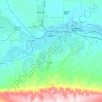
Name: Topografische Karte Casper, Höhe, Relief.
Ort: Casper, Natrona County, Wyoming, United States (42.74294 -106.43495 42.90753 -106.21571)
Durchschnittliche Höhe: 1.725 m
Minimale Höhe: 1.546 m
Maximale Höhe: 2.455 m
Spenden
Andere topografische Karten
Klicken Sie auf eine Karte, um ihre Topografie, ihre Höhe und ihr Relief anzuzeigen.
Casper Mountain
United States > Wyoming > Natrona County
Casper Mountain, an anticline, is located at the north end of the Laramie Mountains overlooking Casper, Wyoming along the North Platte River. At a top elevation of 8,130 feet (2,478 m), the geological feature rises approximately 3,000 feet (914 m) above Casper.
Durchschnittliche Höhe: 2.315 m
Spenden