
Topografische Karte Queens County
Interaktive Karte
Klicken Sie auf die Karte, um die Höhe anzuzeigen.
Über diese Karte
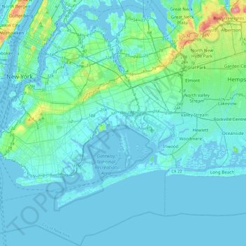
Name: Topografische Karte Queens County, Höhe, Relief.
Ort: Queens County, New York, USA (40.49321 -74.04442 40.81195 -73.70018)
Durchschnittliche Höhe: 11 m
Minimale Höhe: -10 m
Maximale Höhe: 111 m
Andere topografische Karten
Klicken Sie auf eine Karte, um ihre Topografie, ihre Höhe und ihr Relief anzuzeigen.
Staten Island
Staten Island, Richmond County, New York, USA
Durchschnittliche Höhe: 11 m
Roosevelt Island
Roosevelt Island, Manhattan Community Board 8, New York County, New York, 10044, USA
Durchschnittliche Höhe: 13 m