
Topografische Karte Staten Island
Interaktive Karte
Klicken Sie auf die Karte, um die Höhe anzuzeigen.
Über diese Karte
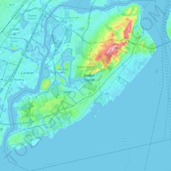
Name: Topografische Karte Staten Island, Höhe, Relief.
Ort: Staten Island, Richmond County, New York, USA (40.49603 -74.25568 40.64889 -74.04925)
Durchschnittliche Höhe: 11 m
Minimale Höhe: -5 m
Maximale Höhe: 122 m
Andere topografische Karten
Klicken Sie auf eine Karte, um ihre Topografie, ihre Höhe und ihr Relief anzuzeigen.
Roosevelt Island
Roosevelt Island, Manhattan Community Board 8, New York County, New York, 10044, USA
Durchschnittliche Höhe: 13 m