
Spenden
Topografische Karte Santiago de Compostela
Klicken Sie auf die Karte, um die Höhe anzuzeigen.
Spenden
Santiago de Compostela
According to a medieval legend, the remains of the apostle James, son of Zebedee were brought to Galicia for burial, where they were lost. Eight hundred years later the light of a bright star guided a shepherd, Pelagius the Hermit, who was watching his flock at night to the burial site in Santiago de Compostela. This site was originally called Mount Libredon [gl] and its physical topography leads prevalent seaborne winds to clear the cloud deck immediately overhead. The shepherd quickly reported his discovery to the bishop of Iria, Theodemir. The bishop declared that the remains were those of the apostle James and immediately notified King Alfonso II in Oviedo. To honour St. James, the cathedral was built on the spot where his remains were said to have been found. The legend, which included numerous miraculous events, enabled the Catholic faithful to bolster support for their stronghold in northern Spain during the Christian crusades against the Moors, but also led to the growth and development of the city.
Spenden
Über diese Karte
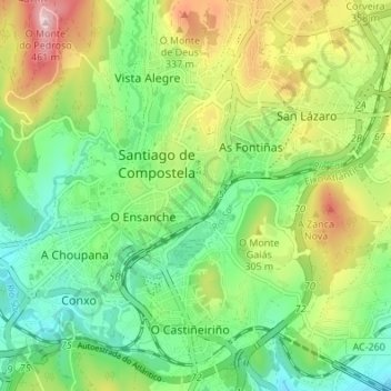
Name: Topografische Karte Santiago de Compostela, Höhe, Relief.
Ort: Santiago de Compostela, Santiago, A Coruña, Galicia, Spain (42.85462 -8.57481 42.89790 -8.50689)
Durchschnittliche Höhe: 260 m
Minimale Höhe: 150 m
Maximale Höhe: 455 m
Spenden
Andere topografische Karten
Klicken Sie auf eine Karte, um ihre Topografie, ihre Höhe und ihr Relief anzuzeigen.
O Campón do Milladoiro
Spain > Galicia > Santiago > Santiago de Compostela > As Moas de Arriba
Durchschnittliche Höhe: 241 m
Spenden