
Spenden
Topografische Karte Carapicuíba
Klicken Sie auf die Karte, um die Höhe anzuzeigen.
Spenden
Carapicuíba
The border with Barueri is a large plain formed by the side of the Rio Tietê. The exploration of sand in the area was so intensive that a large crater was formed. However, during the 1960s, the government of São Paulo state started a series of works to alter the route of the river, and the destruction of the wall between the river and the crater led to the flooding of it. Now, the place has become an artificial lake called "Lagoa de Carapicuíba" (Carapicuíba Lake). 8 thousand litres of sewage from the central, western and southern portions of the city of São Paulo pass through the lake towards Barueri. The average altitude is 717 meters and the climate is in general a humid subtropical climate.
Spenden
Über diese Karte
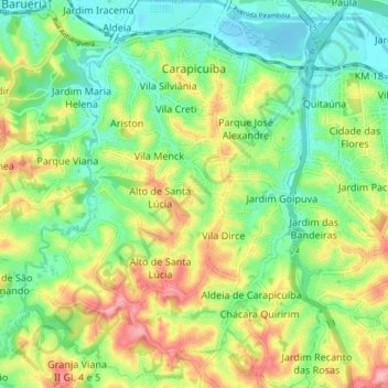
Name: Topografische Karte Carapicuíba, Höhe, Relief.
Durchschnittliche Höhe: 764 m
Minimale Höhe: 714 m
Maximale Höhe: 841 m
Spenden
Andere topografische Karten
Klicken Sie auf eine Karte, um ihre Topografie, ihre Höhe und ihr Relief anzuzeigen.
São Paulo
Brazil > São Paulo > Região Metropolitana de São Paulo > São Paulo
São Paulo is in Southeastern Brazil, in southeastern São Paulo State, approximately halfway between Curitiba and Rio de Janeiro. The city is on a plateau placed beyond the Serra do Mar (Portuguese for "Sea Range" or "Coastal Range"), itself a component of the vast region known as the Brazilian Highlands,…
Durchschnittliche Höhe: 785 m
Praça Tenente Roberto Osaki
Brazil > São Paulo > Região Metropolitana de São Paulo > Osasco
Durchschnittliche Höhe: 731 m
Praça Bartolomeu de Messina
Brazil > São Paulo > Região Metropolitana de São Paulo > São Paulo
Durchschnittliche Höhe: 790 m
Sitio Borda da Mata
Brazil > São Paulo > Região Metropolitana de São Paulo > Franco da Rocha
Durchschnittliche Höhe: 793 m
Spenden
Santo André
Brazil > São Paulo > Região Metropolitana de São Paulo > Santo André
Durchschnittliche Höhe: 776 m
São Bernardo do Campo
Brazil > São Paulo > Região Metropolitana de São Paulo > São Bernardo do Campo
Durchschnittliche Höhe: 760 m
Texas
Brazil > São Paulo > Região Metropolitana de São Paulo > São Paulo
Durchschnittliche Höhe: 834 m