
Spenden
Topografische Karte São Paulo
Klicken Sie auf die Karte, um die Höhe anzuzeigen.
Spenden
São Paulo
São Paulo is in Southeastern Brazil, in southeastern São Paulo State, approximately halfway between Curitiba and Rio de Janeiro. The city is on a plateau placed beyond the Serra do Mar (Portuguese for "Sea Range" or "Coastal Range"), itself a component of the vast region known as the Brazilian Highlands, with an average elevation of around 799 meters (2,621 ft) above sea level, although being at a distance of only about 70 kilometers (43 mi) from the Atlantic Ocean. The distance is covered by two highways, the Anchieta and the Imigrantes, (see "Transportation" below) that roll down the range, leading to the port city of Santos and the beach resort of Guarujá. Rolling terrain prevails within the urbanized areas of São Paulo except in its northern area, where the Serra da Cantareira Range reaches a higher elevation and a sizable remnant of the Atlantic Rain Forest. The region is seismically stable and no significant seismic activity has ever been recorded.
Spenden
Über diese Karte
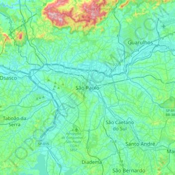
Name: Topografische Karte São Paulo, Höhe, Relief.
Durchschnittliche Höhe: 785 m
Minimale Höhe: 708 m
Maximale Höhe: 1.200 m
Spenden
Andere topografische Karten
Klicken Sie auf eine Karte, um ihre Topografie, ihre Höhe und ihr Relief anzuzeigen.
Parque Estadual da Cantareira
Brazil > São Paulo > Região Metropolitana de São Paulo > São Paulo
There are four visitor centers: Pedra Grande, Engordador, Águas Claras and Cabuçu. The Pedra Grande center has a lookout over the city at 1,010 metres (3,310 ft) of altitude. The park is open for scheduled school groups during the week, and to the general public on weekends. It is an important leisure…
Durchschnittliche Höhe: 841 m
Praça Bartolomeu de Messina
Brazil > São Paulo > Região Metropolitana de São Paulo > São Paulo
Durchschnittliche Höhe: 790 m
Casa Verde
Brazil > São Paulo > Região Metropolitana de São Paulo > São Paulo
Durchschnittliche Höhe: 748 m
Moema
Brazil > São Paulo > Região Metropolitana de São Paulo > São Paulo
Durchschnittliche Höhe: 761 m
Spenden
Morumbi
Brazil > São Paulo > Região Metropolitana de São Paulo > São Paulo
Durchschnittliche Höhe: 761 m
Bela Vista
Brazil > São Paulo > Região Metropolitana de São Paulo > São Paulo
Durchschnittliche Höhe: 796 m
Moema
Brazil > São Paulo > Região Metropolitana de São Paulo > São Paulo
Durchschnittliche Höhe: 761 m
Liberdade
Brazil > São Paulo > Região Metropolitana de São Paulo > São Paulo
Durchschnittliche Höhe: 771 m
Spenden
José Bonifácio
Brazil > São Paulo > Região Metropolitana de São Paulo > São Paulo
Durchschnittliche Höhe: 793 m
Perdizes
Brazil > São Paulo > Região Metropolitana de São Paulo > São Paulo
Durchschnittliche Höhe: 769 m
Mooca
Brazil > São Paulo > Região Metropolitana de São Paulo > São Paulo
Durchschnittliche Höhe: 753 m
Itaim Paulista
Brazil > São Paulo > Região Metropolitana de São Paulo > São Paulo
Durchschnittliche Höhe: 762 m
Spenden
Texas
Brazil > São Paulo > Região Metropolitana de São Paulo > São Paulo
Durchschnittliche Höhe: 834 m