
Topografische Karte Clingmans Dome
Interaktive Karte
Klicken Sie auf die Karte, um die Höhe anzuzeigen.
Über diese Karte
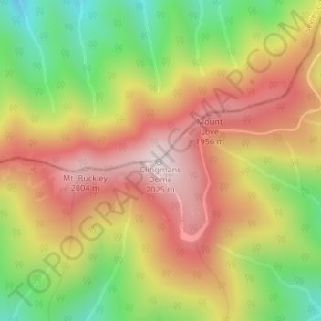
Name: Topografische Karte Clingmans Dome, Höhe, Relief.
Ort: Clingmans Dome, Swain County, North Carolina, United States (35.56281 -83.49843 35.56291 -83.49833)
Durchschnittliche Höhe: 1.716 m
Minimale Höhe: 1.370 m
Maximale Höhe: 2.021 m
Clingmans Dome (or Clingman's Dome) is a mountain in the Great Smoky Mountains of Tennessee and North Carolina in the southeastern United States. Its name in Cherokee is Kuwahi or Kuwohi (ᎫᏩᎯ or ᎫᏬᎯ), meaning "mulberry place." At an elevation of 6,643 feet (2,025 m), it is the highest mountain in the Great Smoky Mountains National Park, the highest point in the state of Tennessee, and the highest point along the 2,192-mile (3,528 km) Appalachian Trail. It is also the third highest point in mainland Eastern North America, after Mount Mitchell (6,684 feet or 2,037 metres) and Mount Craig (6,647 feet or 2,026 metres).
Andere topografische Karten
Klicken Sie auf eine Karte, um ihre Topografie, ihre Höhe und ihr Relief anzuzeigen.
Bryson City
United States > North Carolina > Swain County
Bryson City, Swain County, North Carolina, United States
Durchschnittliche Höhe: 592 m
Smokemont
United States > North Carolina > Swain County
Smokemont, Swain County, North Carolina, United States
Durchschnittliche Höhe: 898 m
Alarka
United States > North Carolina > Swain County
Alarka, Swain County, North Carolina, 28813, United States
Durchschnittliche Höhe: 837 m
Fontana Lake
United States > North Carolina > Swain County
Fontana Lake, Swain County, North Carolina, United States
Durchschnittliche Höhe: 806 m
Rye Patch
United States > North Carolina > Swain County
Rye Patch, Swain County, North Carolina, United States
Durchschnittliche Höhe: 1.190 m
Big Cove Community
United States > North Carolina > Swain County
Big Cove Community, Swain County, North Carolina, United States
Durchschnittliche Höhe: 1.009 m
Cheoah Bald
United States > North Carolina > Swain County
Cheoah Bald, Swain County, North Carolina, United States
Durchschnittliche Höhe: 1.274 m
Almond
United States > North Carolina > Swain County
Almond, Swain County, North Carolina, 28702, United States
Durchschnittliche Höhe: 608 m
Fontana Dam
United States > North Carolina > Swain County
Fontana Dam, Swain County, North Carolina, United States
Durchschnittliche Höhe: 525 m
Nantahala
United States > North Carolina > Swain County
Nantahala, Swain County, North Carolina, United States
Durchschnittliche Höhe: 890 m
Wesser
United States > North Carolina > Swain County > Wesser
Wesser, Swain County, North Carolina, 28702-9603, United States
Durchschnittliche Höhe: 672 m
Whittier
United States > North Carolina > Swain County
Whittier, Swain County, North Carolina, 28789, United States
Durchschnittliche Höhe: 624 m
Cherokee
United States > North Carolina > Swain County > Yellowhill Community
Cherokee, Yellowhill Community, Swain County, North Carolina, 28719, United States
Durchschnittliche Höhe: 746 m