
Topografische Karte Cherokee
Interaktive Karte
Klicken Sie auf die Karte, um die Höhe anzuzeigen.
Cherokee
Cherokee and its surrounding Qualla Boundary is in the very mountainous Swain and Jackson counties. The highest elevation is 6,643-foot (2,025 m) Clingman's Dome at the border with Tennessee. Clingman's Dome is the highest point in the Great Smoky Mountains National Park. The Oconaluftee River flows through downtown Cherokee.
Über diese Karte
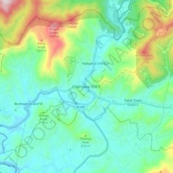
Name: Topografische Karte Cherokee, Höhe, Relief.
Durchschnittliche Höhe: 746 m
Minimale Höhe: 554 m
Maximale Höhe: 1.306 m