
Topografische Karte Caloundra
Klicken Sie auf die Karte, um die Höhe anzuzeigen.
Caloundra
Caloundra, located on Queensland's Sunshine Coast, features a diverse coastal topography characterized by sandy beaches, rocky headlands, and nearby elevated terrains. The suburb of Kings Beach exemplifies this diversity, with its sandy shoreline to the south and southeast, and a rocky headland rising to about 20 meters (66 feet) to the north and northeast. The area is generally hilly, with elevations reaching over 40 meters (131 feet) in certain parts. To the west, the Mooloolah River flows eastward across Glenview towards the coast, with nearby elevations such as Meridan Hill at 140 meters (459 feet) and Mount Sippy at 180 meters (591 feet). Further southwest, Mount Mellum rises to 406 meters (1,332 feet), adding to the region's varied terrain. Additionally, the Pumicestone Passage, a narrow waterway between Bribie Island and the mainland, extends from Caloundra southward for about 35 kilometers (22 miles), contributing to the area's intricate coastal landscape.
Über diese Karte
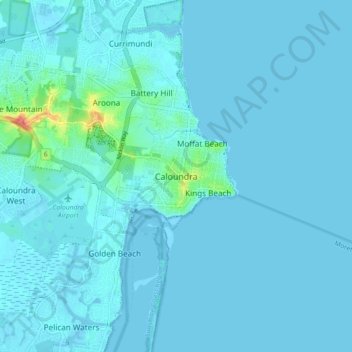
Name: Topografische Karte Caloundra, Höhe, Relief.
Ort: Caloundra, Queensland, 4551, Australia (-26.83816 153.09544 -26.75816 153.17544)
Durchschnittliche Höhe: 5 m
Minimale Höhe: -4 m
Maximale Höhe: 73 m
Andere topografische Karten
Klicken Sie auf eine Karte, um ihre Topografie, ihre Höhe und ihr Relief anzuzeigen.
City of Brisbane
Brisbane's topography is characterized by a series of hills and ranges that define its landscape. The city is situated on a low-lying floodplain, with the Brisbane River meandering through its heart, creating a winding course with many steep curves from the southwest to its mouth at Moreton Bay in the east.…
Durchschnittliche Höhe: 71 m
Brisbane River
The RAAF also perform a practice session in the days preceding the event, serving as an opportunity to both practice beforehand and also promote Riverfire. One of the most popular RAAF aircraft to perform at Riverfire was the F-111 which was known for performing a 'dump-and-burn' above the city. The final…
Durchschnittliche Höhe: 235 m
Roma
Roma experiences a humid subtropical climate (Köppen: Cfa, Trewartha: Cfal); with hot summers with moderate rains; warm to hot, relatively dry springs and autumns; and mild, dry winters. Its location on the far south of the Carnarvon Range at an elevation of 299 metres above sea level means that it is cooler…
Durchschnittliche Höhe: 315 m
Brisbane River
Riverfire, which began in 1998, was a festival held in September each year at South Bank Parklands and surrounding areas (including the Victoria Bridge), to celebrate the Brisbane River. In 2009, the festival merged with Brisbane Festival. Riverfire, which was held at the end of the Brisbane Festival until…
Durchschnittliche Höhe: 44 m
Lama Lama National Park (Cape York Peninsula Aboriginal Land)
Durchschnittliche Höhe: 86 m
Sunshine Coast Regional
The Sunshine Coast Regional area in Queensland, Australia, features a diverse topography that ranges from coastal plains to rugged hinterlands. Along the coastline, the terrain is predominantly flat, with average elevations around 20 meters (66 feet) above sea level. Inland, the landscape transitions to…
Durchschnittliche Höhe: 56 m
Alexandra Hills
Scribbly Gums Conservation Area is located on the eastern edge of Alexandra Hills, bordered by Redland Hospital to the east, and Flinders St and Winchester Rd to the north. The conservation area occupies approximately 152 hectares and contains the Redlands Track Park - a collection of 30+ mountain bike trails…
Durchschnittliche Höhe: 34 m
Stanthorpe
Owing to its elevation, Stanthorpe features a subtropical highland climate (Cfb). At an altitude of 811 metres (2,661 ft), Stanthorpe holds the record for the lowest temperature recorded in Queensland at −10.6 °C (12.9 °F) on 23 June 1961.
Durchschnittliche Höhe: 831 m
Edmonton
The average elevation of Edmonton, Cairns is 16.8 metres (55.1 feet) above sea level.
Durchschnittliche Höhe: 96 m