
Spenden
Topografische Karte Bentonville
Klicken Sie auf die Karte, um die Höhe anzuzeigen.
Spenden
Über diese Karte
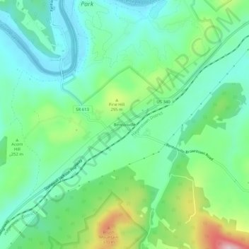
Name: Topografische Karte Bentonville, Höhe, Relief.
Ort: Bentonville, Warren County, Virginia, 22610, United States (38.81142 -78.33682 38.85142 -78.29682)
Durchschnittliche Höhe: 238 m
Minimale Höhe: 160 m
Maximale Höhe: 432 m
Spenden
Andere topografische Karten
Klicken Sie auf eine Karte, um ihre Topografie, ihre Höhe und ihr Relief anzuzeigen.
Front Royal
United States > Virginia > Warren County
Front Royal, located in Warren County, Virginia, sits at an elevation of approximately 570 feet (174 meters) above sea level. It lies in a diverse topographic region, with the town nestled at the confluence of the North and South Forks of the Shenandoah River, which contributes to its distinctive river…
Durchschnittliche Höhe: 194 m
Shenandoah Farms
United States > Virginia > Warren County > Shenandoah Farms
Durchschnittliche Höhe: 250 m
Skyland Estates
United States > Virginia > Warren County > Skyland Estates
Durchschnittliche Höhe: 365 m
Spenden